
| | | | | | | |
| THE BANG KAEO RIVER: RIVER WITHOUT A NAME |
| Text, maps & photographs by Tricky Vandenberg - March 2012 Updated January 2015 |
| | | | | | |
| The Bang Kaeo River (1) is a defunct river which river bed at present still can be traced back along the different irrigation canals east of the Chao Phraya River. In the Ayutthayan era the river had its source at the split of the Chao Phraya River near Bang Kaeo in the same way the Lopburi River had its origin at Bang Phutsa. The river ran in the present Bang Kaeo Canal for 13.5 kilometers and turned southwest at Wat Han Sang. |
| After 500 meter it ran into the present irrigation canal running through Hua Phai of Maha Rat district, Han Sang, Ta Nim, Bang Nang Ra, Khwan Mueang and Phut Lao of Bang Pahan district. From Ban Nonsi in Phut Lao sub-district, the river turned southwest towards Ban Mai and then turned southeast towards Ayutthaya. The Bang Kaeo River joined the old Lopburi River at Hua Laem at the northwestern point of the city in front of Sat Kop Fortress. The irrigation canal spoken of above, starting near Wat Han Sang and running through Ban Chaeng and Ban Ta Nim towards Ban Li (No 2) was named Khlong Bang Chaeng. The waterway from Ban Li (No 2) near Wat Pa Mung through Ban Li (No 3) and Ban Nonsi towards Ban Khlong Phaeng was called Khlong Bang Phaeng. (2) [1] From Ban Khlong Phaeng opposite Ban Mai (2) it continued towards Ayutthaya along Ban Pom. This last water track was referred to as Maenam Ban Pom. [2] |

| (Wat Han Sang) |
| At Ban Nonsi a track split off from Khlong Bang Phaeng in direction of Ban Thai Phai where it breaks up again south of Wat Khok; a western track joining the present Chao Phraya River at Ban Mai Hang Kraben and passing along Wat Jan Prathet and Wat Bamrung Tham; and an eastern track running into Khlong Chang and the former U-loop of the Lopburi River near Wat Kuti Lai. Between the Bang Kaeo River and the Lopburi River were more junctions. On the Lopburi River at Ban Khai (Bang Pahan) in between Wat Ban Khai and Wat Pa Fai ran a canal called Khlong Thom joining Khlong Bang Phaeng in between Ban Li (3) and Ban Nonsi. There are still some traces of this canal visible. We find another connecting canal more north, splitting of at Ban Ta Nim (2) from Khlong Jaeng, passing along Wat Inkalaya and running into the Lopburi River at Bang Pahan. [1] The Maha Phram Canal, linking the old Chao Phraya River (running that time through the present Bang Ban Canal) joined the Bang Kaeo River near Wat Khanon at Ban Khu Mon in a location called before Phak Ku (mouth of the ditch). The western royal tax station was located in this vicinity. In the beginning of the 19th century (1813) there was an attempt to make use of the Bang Kaeo River bed to deviate the Chao Phraya River to Ayutthaya. Van Beek wrote that the Chao Phraya was blocked off near Ang Thong and pushed into the Bang Kaeo Canal. Near Ban Mai (Maha Rat) the waterway was deviated into the Lopburi River via a 1.5 Km long channel. It resurfaced in the Bang Kaeo River bed (Van Beek writes the old Chao Phraya but this seems not possible) near Wat Mai (3), 5 Km south of Wat Chula Mani, but the attempt to give the Chao Phraya a new river bed failed and the project was abandoned. In 1857 a new attempt was undertaken but this time a channel was dug in front of Wat Chula Mani southwards to Ban Mai. The Chao Phraya River followed now a straight course into the last kilometers of the bed of the Bang Kaeo River, replacing the Lopburi River as the main river from Hua Laem onwards. [2] The Bang Kaeo water route is mentioned during the Chiang Mai campaign in the latter part of the epic poem Khun Chang Khun Phaen. [4] The Chronicles of Ayutthaya relate that after having invested the City of Ayutthaya at the end of the White Elephant War (1563-4), King Bayinnaung of Burma (reigned 1550-1581), having imposed harsh terms on Ayutthaya, returned with his armies via the Bang Kaeo River. On Sunday, the ninth day of the waning moon in the fourth month, in the second watch, the appointed time arrived. The King of Præ, the Phraya of Bassein, the Phraya of Lakhœng, the Phraya of Sariang, the Phraya of Tòngu and the Phraya of Cittòng set out with their armies as the vanguard of the retreat. The main army of the King of Hongsawadi proceeded next in sequence and the army of the Uparat followed as the rear guard. The Uparat stationed five hundred cavalrymen to watch over the rear and await developments. If they saw an army of one thousand following them, they were to send one horseman to report; if there were about two thousand soldiers, they were to send two horsemen to report; if there were about three, four, or five thousand soldiers, they were to send three, four or five horsemen, respectively, to report. The [BDEF: vanguard of the] army [BCDF: led the way] [E: proceeded] [BF: along] [CDE: across] the Bang Kaeo Canal and then followed the line of rice fields beside the main river so that the many soldiers, elephants and horses would be able to depend on water. [5] The Bang Kaeo River can be found on some of the older maps such as the one of Jean de Maguelonne de Courtaulin (1686) and Vincenzo Coronelli (1696). Phraya Boran Rachathanin also mentions this defunct river in his work Tamnan Krung Kao. [5] Another waterway separates from the Chao Phraya River at Bang Kaeo and descends to Bang Nang Ra to arrive at Ban Nonsi and go out at the Phut Lao river mouth; joining the waterway which comes from the Lopburi River at the western corner of the capital which is called Hua Laem. In 2012 the Fine Arts Departmen (FAD) restored the ruin of Wat Thai Thalat. A FAD information board in situ near the ruins of Wat Thai Talat states that the temple was located behind a market as its name suggests. The locals traded their products to the Burmese who had their camp(s) in Ayutthaya during the 1766-67 war. As most of the transport was done by water this is again an indication that this was a former natural river linking Ang Thong with Ayutthaya. Six hundred meters to the south of Wat Thai Talat is a mound which once belonged to a defunct temple called Wat Hong. The Bang Kaeo River must have ran behind both temples. Buddhist temple sites along the Bang Kaeo River On the Bang Kaeo Canal we find following Buddhist monasteries: Wat Ban It (R), Wat Su Thadon (R), Wat Rung (L), Wat Tha (R), Wat Klang (R), Wat Thep Suwan (R), Wat Mai Pak Bang (R), Wat Tha To (L), Wat Thammarot (R), Wat Sumei (R) and Wat Han Sang (R). (4) Along Khlong Bang Chaeng: Wat Thai Talat (Wat Talat) (L), Wat Hong (L), Wat Wang Hong (L), Wat Kai (R), Wat Dokmai (R), Wat Ban Chaeng (L), Wat Thep Uppakaram (L), Wat Tanot (R); Along Khlong Bang Phaeng: Wat Pa Mung (R), Wat Nonsi (L) and a defunct temple in grid 642932 (L). Along Maenam Ban Pom (from Ban Mai till Hua Laem in Ayutthaya): Wat Bamrung Tham (L), Wat Ket (L), Wat Pho Phueak (L), Wat Lat Bua Khao (R), Wat Khanon (R), Wat Phra Ngam (R), Wat Chang Thong (L), Wat Pom Yai (R), Wat Pom Noi (R),Wat Chong Lom (L) and Wat Tha (L). Footnotes: (1) There is no known denomination for this waterway, as the river in itself is not more in existence. No name for this river has been found in the Royal Chronicles of Ayutthaya or in other old works. Author took the liberty to call this defunct waterway the Bang Kaeo River, as the river has it source at Bang Kaeo and no important cities were situated along its banks. (2) The number in parenthesis following a village name indicates that more than one village was so named; should be considered as being muban (village/hamlet) of a tambon (sub-district). Ban Li for example counts today 5 villages. At the time of compilation of the map there were only 3 existing. Mostly the villages were built in line along the waterway. (3) I could not trace back this temple, but I presume this was Ban Mai (2) situated at the mouth of Khlong Bang Phaeng and 4 Km south of Wat Chula Mani. (4) (L) and (R) are indicating respectively the left or right bank of the waterway. References: [1] Map L708 Edition 1 RTSD - Sheet 5154 III 47P /EG 11. Map based on aerial photography in 1954, annotated in 1955 and compiled in 1960. The map was not field checked. [2] Our Wars with the Burmese - Prince Damrong Rajanubhab (re-edited 2001) - White Lotus, Bangkok - page 114-115. [3] The Chao Phya, River in Transition - Steve Van Beek - Oxford University Press (1995) - page 11-2. [4] The Tale of Khun Chang Khun Phaen: Siam’s Great Folk Epic of Love and War - Translated and edited by Chris Baker and Pasuk Phongpaichit (2010). [5] Phraya Boran Rachathanin - Tamnan Krung Khao (1907) - pages 93-5. |

| (Water Regulator at the source of the Bang Kaeo Canal) |

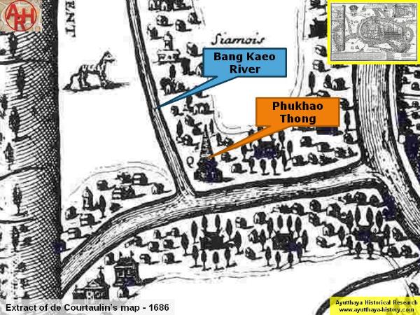
| (The Bang Kaeo River on de Courtaulin's map - Anno 1686) |

| (The Bang Kaeo River on de Coronelli's map - Anno 1696) |


