| WAT KHUN SAEN (วัดขุนแสน) |
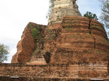
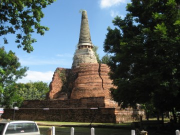
| This deserted temple is located on U-Thong Road, west of the Hua Ror market. Its present day boundary extends right to the base of the road. In fact, one of its chedi stops right before the pavement begins, and motor vehicles actually curve around it. As a restored ruin, Wat Khun Saen has many of its structures remaining. Its highlight is a been expanded over the years, which creates the unique appearance of a small chedi being consumed by a larger one. The view from the chedi’s western side provides an idea about how these temples were sometimes expanded over preexisting structures. In situ, there is also the basic foundation of a sermon hall, which includes pieces of Buddha images and some sema stone. Portions of a wall can be seen surrounding the monastery. Traces of several small chedi can also be seen on the premises, including the one located right next to U-Thong Road. There are a number of large and interesting Bodhi tree on site. There isn’t a clear record of this temple’s construction date, but King Maha Thammaracha (r. 1569-1590) persuaded two Mon aristocrats and their families to settle in this area around 1584. This honor was in reward for their participation in Prince Naresuan’s declaration of independence from the Burmese. The two Mon warriors were named Phraya Kiat and Phraya Ram. Royal Chronicles describe this story in great detail. While still technically allied with the King Honsawadi of Burma, Prince Naresuan marched his troops to the City of Khraeng, where they encamped near the monastery of the Great Holy Tera Khan Chong. King Honsawadi, in the meantime, set up a plan to betray Prince Narasuaen - sending out an army of 10,000 to ambush and kill him. Phraya Kiat and Phraya Ram were told by the Burmese King Hongsawadi to make a flanking attack from the rear. Their orders were to attack Prince Naresuan, seize his troops, and execute him (Cushman 88). However, the Great Holy Tera Khan Chong was informed of this treachery and took pity on Prince Naresuan. He arranged a meeting between Phraya Kiat, Phraya Ram, and Prince Naresuan in which all was revealed. As a result, Prince Naresuan declared revenge and announced that the two kingdoms “shall be totally divorced from each other from this day to the end of kalpa.” (Cushman 89). He promised to escort the two Mon leaders and the Holy reverent to the safety of Ayutthaya - fighting together against the Burmese along the way. While leading the Great Holy Thera Khan Chong and his relatives - and the families of Phraya Kiat and Phraya Ram - back to Ayutthaya, Prince Naresuan defeated the enraged Burmese in battle and Ayutthaya became independent once again. King Maha Thammaracha (r. 1569-1590), the father of Prince Naresuan, rewarded the Mon families in gratitude. Phraya Kiat and Phraya Phra Ram were directed to reside in the vicinity of the Khamin Village and Wat Khun Saen. The relatives of Tera Khan Chong were sent to live in a village behind Wat Nok (Cushman 90). In more recent times, King Rama IV (1851-1868) ordered Phraya Rajasongkram to restore Wat Khun Saen and enlarge its central bell-shaped chedi. However, the King died before this project could be finished. As a result, the restoration of Wat Khun Saen was permanently halted and the monastery has remained inactive ever since (TAT 110). |

| | | | | | | | |
| Text by Ken May - August 2009 Photographs by Tricky Vandenberg & Ken May |
| | | | | | | |
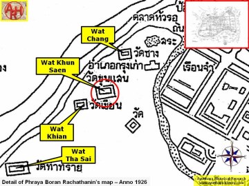
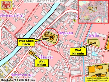
| Addendum 1 Wat Khun Saen is a restored ruin situated on the city island outside the Historical Park in Hua Ro sub-district. The monastery is indicated on a map drafted in the 19th century and on Phraya Boran Rachathanin's map drafted in 1926. Wat Song and Wat Racha Phruek stood in its immediate vicinity. Khamin village was located next to Wat Khun Saen, while Wat Khamin was likely its village temple. The village must have existed prior the first fall of Ayutthaya in 1569 outside Ayutthaya's city wall. Around 1580 the village became enclosed within the walls. "Then Phraya Kiat and Phraya Phra Ram were directed to reside in the vicinity of Khamin Village [B: on the edge of] [CDEF: and] Khun Saen Monastery." [1] Hengpujaroen wrote that according to some old documents, the walls around the Chan Kasem Palace or Front Palace had a length of 50 Sen or approximately 2000 m. The palace occupied thus an area roughly going from the Unmilled Rice Fort (Pom Khao Phluak) and Wat Tha Sai towards the Maha Chai Fort; going down to the Ho Ratanachai Gate and running back along the Ho Ratanachai canal towards the Unmilled Rice Gate. The palace area should have included at least eight monasteries, which one of them was Wat Khun Saen. The issue of a such large palace ground as mentioned here, was although heavily discussed by scholars and rejected. [1] In the "Geographical description of Ayutthaya: Documents from the palace" we read that Wat Khun Saen was a monastery inside the palace with an ubosot (ordination hall), a vihara (preaching hall), a teaching hall (kanparien), a reliquary stupa (Phra That) and a number of satellite chedi. As this was a monastery inside the palace there were no monks residing identical to the monastery of the Grand Palace, Wat Sri Sanphet. This confirms partly the writings on the Front Palace by Hengpujaroen. [3] Wat Khun Saen is located in Geo Coord: 14° 21' 55.05" N, 100° 34' 15.84" E. References: [1] The Royal Chronicles of Ayutthaya - Richard D. Cushman (2006) - page 90 / Source: Phan Canthanumat, British Museum, Reverend Phonnarat, Phra Cakkraphatdiphong & Royal Autograph - Naresuan and Hongsawadi Fight, and Naresuan Returns to Ayutthaya. [2] The study of Chantharakasem Palace for developing the Management Plan - Nantana Hengpujaroen (2003). [3] Phanna Phumisathan Phra Nakhon Si Ayutthaya: Ekkasan jak ho luang [Geographical description of Ayutthaya: Documents from the palace]. Edited by Winai Pongsripian. Bangkok: Usakane, n. d. [2007] - page 56. |
| Addendum & maps by Tricky Vandenberg - November 2010 Last update December 2014 |
| (Wat Khun Saen seen from the west) |
| (Attempt undertaken to enlarge the main chedi) |
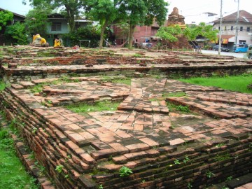
| (View of the premises from the east) |
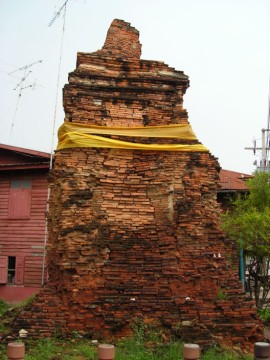
| (Satellite chedi in situ) |
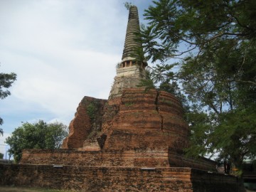
| (View of the main chedi of Wat Khun Saen) |
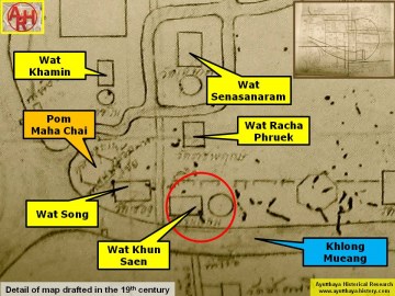
| (Detail of a 19th century map - map is orientated S-N) |
| (Detail of Phraya Boran Rachathanin's map - Anno 1926) |
| (Detail of a 2007 Fine Arts Department GIS map - Courtesy of the Fine Arts Department - 3th Region) |


