| WAT NANG (วัดหนัง) |

| | | | | | | | |
| Wat Nang or the Monastery of the Hides was located on the city island, outside the Historical Park of Ayutthaya in the east part of the city, in present Ho Ratana Chai Sub- district. The monastery was situated on the south bank of Khlong Pratu Ho Ratanachai and on the west bank of Khlong Nai Kai, presently called Khlong Makham Riang and stood south of Wat Senasanaram also called Wat Senat. To its east were the defunct Wat Khwang and the still active monastery Wat Prasat. There are no traces anymore visible of the monastery above ground level. Historical data about the monastery and its construction are unknown. Wat Trae is mentioned in the Royal Chronicles of Ayutthaya around 1663. There was a rivalry between the royal page Chai Khan and Phra Phetracha. Chai Khan boosted against King Narai (r. 1656-1688) he was superior in a certain game, hinting especially at Phra Phetracha. King Narai aware of the rivalry designated, a day for a contest in the elephant- horse chase (1). The game started near Wat Trae and the run went parallel along the Makham Riang Canal until Wat Nang. The first round was won by Phra Phetracha on horse back. Chai Khan, realizing he was losing face, skipped the second round and went home. [1] The next morning His Majesty held court and all of the marshals attended together. Master Chai Khan, a royal page and the son of a holy nurse, prostrated himself and said to His Holy Grace, “In the display of chase elephant and bait horse, outside the sole exception of the Supreme Holy Lord Omnipotent, there is no-one I am afraid of.” The Supreme Holy Lord Omnipotent was aware that Master Chai Khan was intentionally and maliciously comparing himself to Phra Phet Racha and that Phra Phet Racha was equally knowledgeable, and so He answered Master Chai Khan by saying, “You would each take a turn riding the chase elephant and the bait horse, wouldn’t you?” Master Chai Khan said, “I’ll ride the chase elephant first.” Phra Phet Racha was agreeable. When the designated day arrived, Master Chai Khan rode the premier elephant Phaya Sower of the Three Realms, standing six sòk and six niu high, and Phra Phet Racha rode the horse Mountain of Time, standing three sòk and two niu high. The arena was laid out in the vicinity in front of the Monastery of the Trumpets with the horse and elephant one sen apart. Phra Phet Racha reined his horse into a baiting display. Master Chai Khan drove his elephant and chased him on up close to the Bridge of Bricks at the Monastery of the Hides, and the elephant reached for him. Phra Phet Racha, seeing it almost upon his person, drove his horse into Little Spire Alley and the elephant was left behind. When it was the turn of Phra Phet Racha to ride the elephant, Master Chai Khan fled off to his home. Phra Phet Racha came in for an audience, prostrated himself, spoke to the Holy Lord Omnipotent and related the substance of that entire matter so the King would be informed of all the details. The Supreme Holy Lord Omnipotent said, “Weren’t you aware that that little Chai Khan is a soldier [only] in talk? The site is indicated on a map drafted in the mid-19th century, but not on Phraya Boran Rachathanin's map of 1926. The mid-19th century map indicates the existence of a chedi. Wat Nang must have been located in approx. Geo Coord: 14° 21' 45.46" N, 100° 34' 25.07" E. Footnotes: (1) The game was a re-enacting of an ancient method of catching wild elephants. A horse acts as bait to anger the elephants, then leads them into a log trap. Upon level ground an elephant can overtake a horse; upon ascent the horse has the advantage. References: [1] The Royal Chronicles of Ayutthaya - Richard D. Cushman (2006) - page 168-9 / Source: Phra Cakkraphatdiphong - Rivalry of Phra Phet Racha and Chai Khan. |
| Text, maps & photograph by Tricky Vandenberg - July 2010 Updated January 2015 |
| | | | | | | |
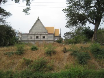
| (Location where once Wat Nang stood) |
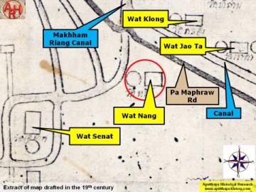
| (Detail of a 19th century map - map is orientated S-N) |
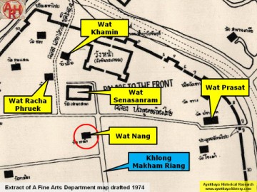
| (Detail of a 1974 Fine Arts Department map - Courtesy Dr. Surat Lertlum, Chulachomklao Royal Military Academy) |
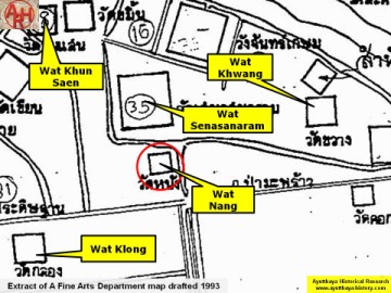
| (Detail of a 1993 Fine Arts Department map - Courtesy Khun Supot Prommanot, Director of the 3th Regional Office of Fine Arts) |
