| WAT THA PHAI (วัดถ้าพาย) |

| | | | | | | | |
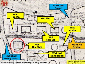
Wat Tha Phai or the "Monastery of the Landing of the Paddle" is a vanished temple
formerly located on the city island in present Pratu Chai sub-district, in the vicinity of an
area formerly called Laem Sarapha. The monastic structure was located near "China
Street" and Khlong Nai Kai, presently called Khlong Makham Riang.
Following a map of the 19th century, the monastery was situated north of Wat Tha Ma
on the opposite side of "China Street". To the north stood Wat Trae and to the northwest
Wat Noi Nang Hong (1).
Historical data about the monastery and its construction are unknown. The 19th century
map indicates no existence of a chedi or prang.
The temple is mentioned on Phraya Boran Rachathanin's (PBR) map drafted in 1926 as
Wat Singthai (วัดสิงหทาย). Its name has been presently altered to Wat Singha Sai
(วัดสิงหาทราย), maybe referring to lions in sandstone found on the former temple
grounds.
Making an assessment off all the monastic structures, in the zone demarcated by Chikun
Rd, Pa Thon Rd, Pridi Banomyong Rd and U-thong Rd is rather difficult, as the position
and name of the structures varies on different maps. On a 19th century map there are 15
structures counted, while on the 20th century PBR map there are 13 mentioned. There is
inconsistence in the names and the positions. Even a map drafted in the 90's by the Fine
Arts Department, what I presume, based on excavations in the zone, shed no light on this
matter. Positions of monastic structures can be asserted, but their ancient names will
remain questioned forever.
Footnotes:
(1) Phraya Boran Rachathanin positions Wat Noi Nang Hong more north than the 19th
century map does. The location of Wat Noi Nang Hong on the 19th century map is
called Wat Jin by PBR.
| Text & map by Tricky Vandenberg - November 2010 |
| | | | | | | | |