
| | | | | | |
| | | | | | | |
| MUEANG KANBURI (เมืองกาญบุรี) |
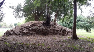
| (Ruins of NNW fortress) |
| Photographs, text & maps by Tricky Vandenberg March 2016 |
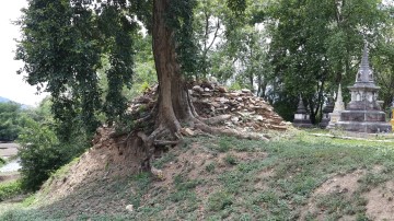
| (Ruins of the SSW fortress) |
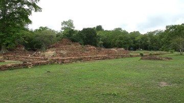
| (Ruins of Wat Khun Phaen) |
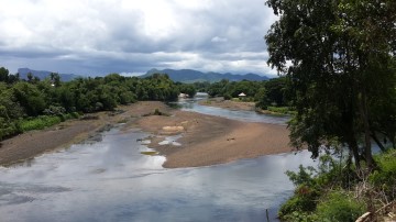
| The ancient town of Kanburi could date back to the period the Khmer ruled the Maenam basin from Lopburi in the late 12th century. Mueang Singh, an ancient Khmer city dating from the reign of King Jayavarman VII (reign 1177-1237 AD) was situated in a strategic position along the Khwae Noi River with Mueang Krut, another Khmer town about 4.5 Km to its east. Likely there was a trade route between Tavoy (1) and Kan Buri to Lopburi since the Khmer period. Kan Buri is situated on the same NE-SW axis as both Khmer cities in relation to the western passages over the Tenasserim Range. The route from the Three Pagoda Pass (2) to Kan Buri was the most important route along the western border. Kan Buri was strategically important being situated along a war route directly connected to Ayutthaya and which was used more than 20 times from the 16th till the 20th century. [1] The old town is located in Lat Ya Sub-district of Kanchana Buri. Kan Buri was strategically located at the confluence of the Mae Klong River, along a stretch called since last century the Khwae Yai River, and the Taphoen River. The town was situated in a grassy plain at the foot of the 220 meters high Khao Chon Kai (Cockfight Hill). Kanburi must have been an important border and trade post as well as a garrison town to protect the western and north-western flank of the Ayutthaya Kingdom. It was a fortified town, surrounded with a rectangular earthen wall measuring 167 meters by 355 meters. Remnants of the four corner fortresses still can be seen today. A number of ruins of old temples can be found on the northern side of the town. Kanburi is for the first time mentioned in the Royal Chronicles of Ayutthaya on the event of the Burmese invasion of 1548-1549 by King Tabinshwehti of Taungo. The Burmese forces entered the Kingdom of Ayutthaya through the Three Pagoda Pass and attacked the western frontier post of Kan Buri. The provincial town was no match for the large Burmese forces on the way to Ayutthaya. The attack of Ayutthaya finally did not take place and the Hongsawadi Army retreated after encamping three days at Thung Lumphli. The King of Hongsawadi then moved his army in swiftly by way of the Three Pagodas Pass and attacked Kancanaburi. Captured officials, under questioning, [BCDF: testified] [E: stated] that it was true that the Capital had been in confusion, but that at present Prince Thianracha was on the royal throne, and that all the ministers and counselors, and all the provinces, were united and at peace. The King of Hongsawadi declared that, “We have come too far [BDEF: at this point] already. If we simply go home, it will look as though we have no dignity at all. We will [CDEF: have to] go on in [BCDE: until we have trod] [F: and tread] on the outskirts of the city. As soon as we have seen the Capital we will return. In addition, we will get to observe the skill of the soldiers of Ayutthaya and see which people come out to meet our army.” [BCDF: Having spoken,] [E: So] he took his army to [BCD: attack] [EF: capture] Suphanburi. Then, crossing the plain, he entered [BCEF: at the back of] Mok Forest, traversed it with his men, and went on to establish his main stockade in the Municipality of Lumphli. [2] Ruins of temples Wat Pa Lelai is locally known as Wat Pha Ok. The mondop once enshrined a seated Buddha image in the gesture of subduing Mara, which was drilled through the chest - ‘Pha Ok’ in Thai. An image of the Buddha receiving offerings from a monkey and an elephant known as ‘Palilayaka’- Pa Lelai - was later constructed to replace the former one. Remains of architecture within the temple include a mondop, a vihara and a round brick chedi with clay mortar and cement coating. Wat Khun Phaen includes a prang, an ordination hall, a vihara and satellite chedi. Wat Mae Mai (Nua) is located some 300 meters to the east of Wat Khun Phaen. There are 2 groups of architectural remains. The remains in the north include a large round Chedi situated on a plinth and rectangular west-facing vihara. The remains in the south include a medium-scale east-facing vihara, satellite chedi and rectangular boundary wall, with a so- called ‘Sa Lang Kraduk’ or ‘bone-washing’ pond in between. The latter is called Wat Kanchanaburi or Wat Mae Mai Tai. Kanburi is mentioned in the long narrative poem about love and death Khun Chang Khun Phaen as the place were Phlai Kaeo (the later Khun Phaen) and his mother Thong Prasi had to flee after the execution of his father Khun Krai Phonlapai. The king of Ayutthaya gave order to seize Thong Prasi, but she was timely warned and fled from Suphanburi. Phlai Kaeo remained in Kan Buri until he became fifteen. At a later stage he would become the Governor of Kan Buri; hence the names for some temples in the area related to the epic poem (Wat Khun Phaen, Wat Nang Phim). The old town of Kanburi is located in geographical coordinates: 14° 6' 55.38" N, 99° 23' 58.96" E. Footnotes: (1) Tavoy, today called Dawei, was part of the Ayutthaya Kingdom since its establishment. It was lost to the Burmese in 1564 after the White Elephant War. Tavoy was taken back in 1594 and lost again in the next century. In 1740 the area came back under Siam, but was lost again in the Siamese - Burmese war of 1760. (2) The pass north of Sangkhla Buri was used since olden times as the easiest point to cross the Tenasserim Hills into the central plains of the Chao Phraya. The war route started in Martaban (Mottama) and followed the Ataran River (known as Mae Kasat by the Siamese) until its source at the confluence of the Winyaw and Zami rivers. From there it went over land to the pass and further down to the confluence of the Noi, Lante and Bikhi Rivers. From this point it went by boat to Sai Yok, crossing over land to the Mae Khlong (Khwae Yai today) and then further down to Kan Buri. [3] Over the centuries, traders and migrants using the pass marked their passage by adding a stone to the stacks and the pass became known as Hin Sam Kong (Three Cairns). In 1929, the ruler of Sangkhla Buri, sent up people to arrange the three piles of stones properly and got them cemented into the form of a stupa, hence today's naming of the pass the Three Pagoda Pass. It has to be mentioned that although today the three chedi are wrapped in orange cloth (sabong), they have no religious status as the stupa never contained relics and are considered as markers. The wrapping of the cloth should be viewed in the same way as some monks try to protect trees from felling by wrapping a sacred cloth around the trunk. In an event occurred in King Narai's reign around 1662, the Royal Autograph Chronicle of Ayutthaya mentions that there was a customs station at the Three Pagoda Pass. [4] References: [1] Pongsawat, Pitch - Border Partial Citizenship, Border Towns, and Thai-Myanmar Cross-border Development: Case Studies at the Thai Border Towns (2007). [2] Cushman, Richard D. - The Royal Chronicles of Ayutthaya (2006) - page 27-8 / Source: Phan Canthanumat, British Museum, Reverend Phonnarat, Phra Cakkraphatdiphong & Royal Autograph - War With Burma, Early 1549. [3] Rajanubhab, Damrong - Our Wars with the Burmese (1917) - White Lotus, Bangkok (2000). [4] The Royal Chronicles of Ayutthaya - Richard D. Cushman (2006) - page 257 / Source: Royal Autograph. |

| (Ruins of Wat Mae Mai Nuea) |
| (Ruins of Wat Mae Mai Tai) |


| (Ruins of Wat Pa Lelai) |

| (View of Cockfight Hill) |

| (Inside the monastic hall of Wat Pa Lelai) |


| (View from the SSE fortress) |

| (The Three Pagoda Pass Anno 1945 - Source: Australian War Memorial) |