| WAT JAO PRAP (วัดเจ้าปราบ) |
| Wat Jao Prap is situated in Somdet Phra Sri Nakharin Park, in the southwestern area of the city island. It can be seen from U-Thong Road, near the mouth of Khlong Chakrai Yai. This canal was once an important route for accessing the Grand Palace, and it would have been used by kings for transportation. This monastery's name refers to a royal dressing area for visiting a temple; and the remains of a Phlabphla or pavilion is still visible in the corner of the site (adjacent to Khlong Chakrai Yai). An ubosot is located at this site, and a large bell-shaped chedi is its primary feature (suggesting the Middle Ayutthaya period). An inner wall surrounds the ubosot. This wall includes many niches where lanterns or Buddha images could have been placed. There is also a clear trace of an outer wall that includes entrance gates. A number of smaller chedi can be seen at this site. Two of these have a dramatic appearance outside of the inner walls. One is in the late period Khmer-style with many redentations. A second chedi is nearly completely covered by a Bodhi tree that has grown over it. Only its general shape and a few bricks can be seen. The Fine Arts Department has listed Wat Jao Prap as being constructed in the Early Ayutthaya period, but evidence for this claim is unclear. The area around this monastery was once used by bodyguards, police, and soldiers. An armory was once located at the mouth of Khlong Chakrai Yai near this monastery, but it has since been destroyed due to the construction of a water gate. The name of this temple is supposedly mentioned in an old book used by military troops. |

| | | | | | | | |


| Text by Ken May - May 2009 Photographs by Tricky Vandenberg |
| | | | | | | |
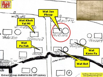
| Addendum Wat Jao Phrap is indicated on a mid-19th century map on the same location as Phraya Boran Rachathanin does on his 1926 map. The name of the temple does not refer to a royal dressing area for visiting a temple as written above. Chao (Jao) Phrap stands for "Lord Conqueror" and the temple's name can as thus be translated as the "Monastery of the Lord Conqueror". Often temples were named after their founders. Whether the denomination refers to the Buddha or a to member of the royal family at that time, I leave in the middle. The remains of the pavilion mentioned above are the ones of a storehouse or depository. Dibuk (ดีบุก) meaning tin. Phraya Boran Rachathanin mentions คลังดีบุก , which refers as thus to a depository of tin. The site is situated in geographical coordinates: 14° 20' 30.46" N, 100° 33' 20.29" E. |
| Addendum by Tricky Vandenberg - March 2011 |


| (Klang Dibuk or Tin Depository) |
| (Wat Jao Phrap from the north) |
| (View of Wat Jao Phrap) |
| (Entrance gate in the outer wall) |
| (Wat Jao Phrap from the east) |


| (Detail of a 2007 Fine Arts Department GIS map - Courtesy of the Fine Arts Department - 3th Region) |
| (Detail of a 19th century map - Courtesy Sam Chao Phraya Museum) |
| (Detail of Phraya Boran Rachathanin's map - Anno 1926) |


