| WAT KHAMIN (วัดขมิ้น) |
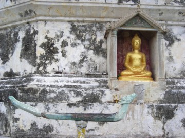
| Wat Khamin is a temple ruin located on the city island near Hua Ro market. It was once contained inside the boundaries of the former provincial prison. Many of the prison’s surviving walls and turrets shield it from easy viewing. This temple gets its name from the sound of crying crows. In situ is a large bell shaped chedi with an octagonal base. It has a niche in its northern side where a small Buddha image has been placed. The chedi has been painted white at one time (though the paint is now badly chipped and peeling), and a number of modern images decorate its base. There are also hints of a sermon hall, but only at the ground level beside the chedi. Also on the premises is a small shrine containing on Buddha image in the Taming Mara pose. On the north-eastern corner there is a small, square-shaped, brick structure; however, this and some of the other structures in situ could actually be part of the old prison. It is unclear when Wat Khamin was originally established, but Royal Chronicles first mention it in relation to a village under that same name where Mon families were given property to live upon. As the story goes, King Honsawadi of Burma had set up a plan to betray Prince Naresuan - sending out an army of 10,000 to ambush and kill him. Two Mon military leaders, Phraya Kiat and Phraya Ram, were ordered to attack Prince Naresuan’s troops and execute him (Cushman 88). However, after the treachery was revealed, a Holy monk (Tera Khan Chong) convinced the two Mon generals to disobey these orders. They sided with Prince Naresuan, who then declared Ayutthaya independent from the Burmese. King Maha Thammaracha (r. 1569-1590), the father of Prince Naresuan, decided to reward the Mon military leaders for their participation in this conflict. Phraya Kiat and Phraya Phra Ram were directed to reside in the vicinity of the Khamin Village and Wat Khun Saen. The relatives of Tera Khan Chong were sent to live in a village behind Wat Nok (Cushman 90). Wat Khamin also played an important role in the fall of Ayutthaya in 1767. Wat Khamin was located behind the fortress Pom Maha Chai, a vitally strategic point for both Siamese and Burmese armies. The Burmese military leader Nemiao had all his army masters advance forward to establish stockades at the Monastery of the Gold Mountain, the Village of the Fort, and at the Monastery of the Crying Crow. Ayutthaya staged a counter attack against the Burmese in front of this monastery. However, after a single man was killed, Master Roek, who was standing at the front of the boat while dancing with swords in each hand, the Siamese boat army promptly retreated (Cushman 511). Later during the siege, the Burmese built an embankment that crossed the river in front of the Monastery of the Crying Crow. They then started to dig a tunnel curving under the base of the walls while Siamese troop fired upon them with long guns (Cushman 518). Royal Chronicles mention that the Burmese fired guns at fortresses in front of the “Monastery of the Landing of the Crying Crows” (Cushman 520). The walls caught fire and collapsed. On April 7, 1767, Burmese troops finally entered the city and ransacked it. The kingdom of Ayutthaya was permanently destroyed. In modern times, Wat Khamin has inherited its own legend. A provincial prison was established on the site of the old monastery. Modern prison cells soon filled with convicts, at the location where the Burmese had once breached the city walls earlier. The prison has since closed down, but many of its walls and guard towers can still be seen. The local legend is that Wat Khamin (Monastery of the Crying Crows) received its name because crows would wildly screech whenever a convict was executed. |

| | | | | | | | |
| | | | | | | |
| Text & photographs by Ken May - August 2009 |
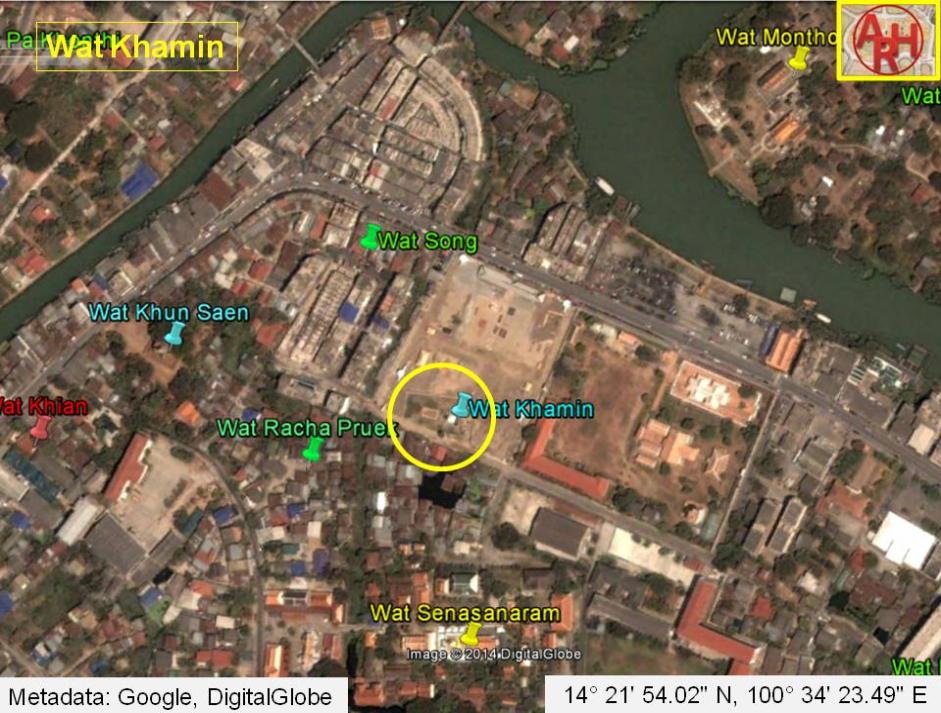
| Addendum Khamin is the Thai word for Curcuma and as thus has no relation with crows or with the "Monastery of the Landing of the Crying Crows" as stated above. Curcuma is a plant, a genus in the ginger plant family Zingiberaceae having its habitat in the warm, humid environments of south and southeast Asia. The most commercially important kind is Curcuma Longa, originating from India, widely cultivated in Asia for its underground stems. The stems are boiled for several hours and then dried in hot ovens, after which they are ground into a deep orange-yellow powder commonly used as a spice in curries and other South Asian cuisine. It is also used for dyeing and to impart color to mustard condiments. The root of turmeric (Curcuma Longa) has long been used in traditional Asian medicine to treat gastrointestinal upset, arthritic pain, and "low energy." Ban Khamin was a hamlet on the northeastern tip of Ayutthaya's city island at a time that Ayutthaya's eastern city wall ran along Khlong Nai Kai (Khlong Makham Riang) and the connection canal (in front of the later Maha Chai Fortress) between the old Lopburi River and the eastern city moat (Khu Khua Na) was not yet dug. Ban Khamin could have been a place where curcuma plants were prepared to be sold as spices or medicine. Wat Khamin must have been the local temple of Ban Khamin. Whether the temple became part of the Front Palace area at a later stage or not, remains a point of discussion. The village is mentioned in the Royal Chronicles of Ayutthaya [1]. "Then Phraya Kiat and Phraya Phra Ram were directed to reside in the vicinity of Khamin Village [B: on the edge of] [CDEF: and] Khun Sæn Monastery. The relatives of the great holy Thera Khan Chòng [BCF: were directed to live] [DE: lived] in the vicinity of a village behind Nok Monastery." [1] Wat Khamin features curiously enough not on Phraya Boran Rachathanin's map drafted in 1926, but is indicated on a map drafted in the mid-19th century. The restored ruin of Wat Khamin is located in Geo Coord: 14° 21' 54.02" N, 100° 34' 23.49" E. References: [1] The Royal Chronicles of Ayutthaya - Richard D. Cushman (2006) - page 90 / Source: Phan Canthanumat, British Museum, Reverend Phonnarat, Phra Cakkraphatdiphong & Royal Autograph - Naresuan and Hongsawadi Fight, and Naresuan Returns to Ayutthaya. |
| Addendum & maps by Tricky Vandenberg - August 2010 Updated June 2014 |
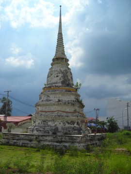
| (Chedi of Wat Khamin) |
| (Chedi of Wat Khamin) |
| (Detail of Chedi Wat Khamin) |
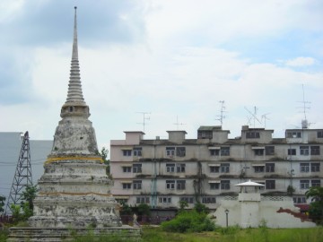
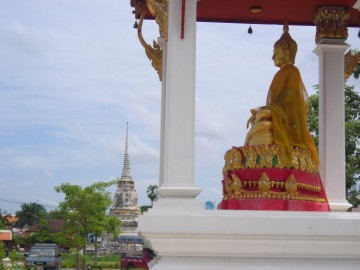
| (View of Wat Khamin) |
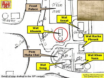
| (Detail of a 19th century map - Courtesy Sam Chao Phraya Museum) |
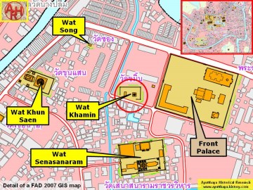
| (Detail of a 2007 Fine Arts Department GIS map - Courtesy of the Fine Arts Department - 3th Region) |


