| WAT KRABUE (วัดกระบือ) |
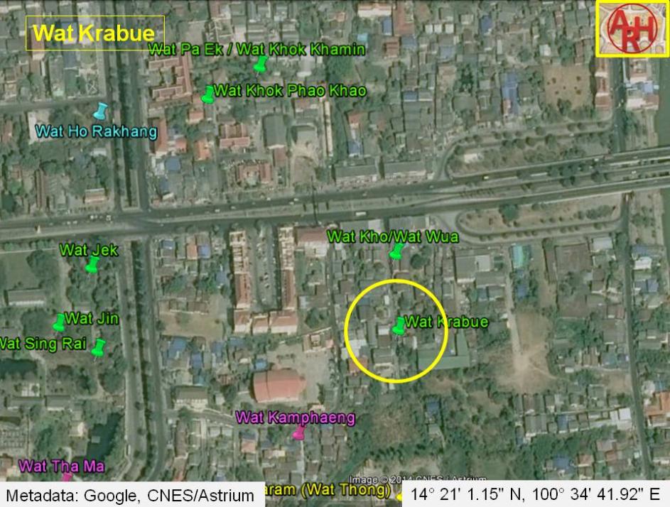
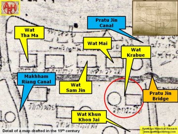
| Wat Krabue or the Monastery of the Buffalo was located on the city island in the eastern area of Ayutthaya in Ho Ratana Chai Sub-district. The temple was situated north Riang. Wat Kho and Wat Krabue lie just opposite of each other while Wat Ho Rakhang was situated in its north-west. The monastery is mentioned in the Royal Chronicles of Ayutthaya. It was in this area that the Siamese army of Phra Maha Thep retreated and regrouped after their stockade on Crystal Island was overrun by the Burmese in their attack of Ayutthaya in 1569. The Burmese principal effort seems to have occurred in the south east as the northern, western and southern flanks of the city were protected by the rivers, being a natural barrier. The eastern side of the city was easily prone to attack as no real defense line existed. The Pa Sak River did not change its course yet, and a large tract of land - only partially cut by some shallow irrigation canals - lie in front of the city. The troops of Prince Thammaracha from Phitsanulok and the Burmese Uparat (second to the King of Hongsa) advanced over Kaeo Island (Crystal Island - the actual location of Wat Ko Kaeo) towards the city. The army of Phra Maha Thep was routed and he retreated to regroup in the area in front of Kho Monastery and Krabue Monastery. Being routed again and withdrawing to regroup in the vicinity of Phao Khao Monastery, his broken forces were so scattered and repeatedly separated that they could not reform their lines. The enemy thus, was able to enter the city of Ayutthaya on 30 August 1569, leading to its first fall. (See: The eastern city limits of Ayutthaya in 1569) "The King of Hongsawadi, being so informed, designated all the [CDEF: highranking nobles,] military officers [CEF: and soldiers] who were to [BCDF: go in to] take the Capital and organized his soldiers into four divisions. One division, dressed in black tunics, was armed with sword and shield; another division, dressed in green tunics, was armed with a sword in each hand; a third division, dressed in red tunics, was armed with matchlocks; the last division, dressed in purple tunics, was armed with spears [BDEF: , tasseled lances,] and swords worn suspended from one shoulder down across the chest. Then the King of Hongsawadi ordered Prince Thammaracha and the Uparat to command these troops and lead them in along the Kæo Island causeway, and the King of Ava and the King of Præ to advance from their positions, so that they all advanced along the three causeways at the same time. The officials sent down a rain of flaming arrows, long pointed iron bars, and long sharpened bamboo sticks which hit and killed the [BEF: Hongsawadi] soldiers in great numbers. The enemy troops, however, did not retreat, but unceasingly pressed forward and steadily reinforced each other. The noise of the troops and the din of the guns resounded as though the earth were quaking. And the army of Prince Thammaracha and the Uparat attacked, forced their way into and captured the stockade of Phra Maha Thep. Phra Maha Thep was routed and retreated to regroup in the area in front of Kho Monastery and Krabü Monastery. Being routed again and withdrawing to regroup in the Vicinage of Phao Khao Monastery, his broken forces were so [B: scattered and] [CDEF: repeatedly] separated that they could not reform their lines and the enemy was able to enter the city." [1] There are no traces any more of the former monastery and it is classified as disappeared. The exact date of its construction is not known. Wat Krabue is shown on two old maps in a different location. Following a map of the 19th century the monastery was situated along the east bank of Khlong Pratu Jin and north of the road running over the Pratu Talat Jin Bridge. On the opposite site stood the presently defunct Wat Mai, while on its east side was the also presently defunct Wat Noi Nang Hong. To the north stood Wat Khun Khon Jai, presently called Wat Khun Mueang Jai, a still existing restored ruin. The map indicates the existence of a chedi. I believe the location of Wat Krabue on Phraya Boran Rachathanin's (PBR) map drafted in 1926 is the most plausible as it supports the events in the Royal Chronicles of Ayutthaya. His map indicates that at that time a brick road ran in between Wat Kho and Wat Krabue. This brick road at a later stage in the 20th century became the Rojana Rd. The location of Wat Krabue on the mid-19th century map corresponds more or less with Wat Pa Ek on PBR's map, but it could also have been one of the structures he indicated as Wat Tha Jin, Wat Khanom Jin or Wat Cho Ae, south of Wat Khun Mueang Jai. Making an assessment of all the monastic structures, in the zone demarcated by Chikun Road, Pa Thon Road, Pridi Banomyong Road and U-Thong Road is rather difficult, as the position and name of the structures vary on different maps. On a 19th century map, there are 15 structures counted, while on the 20th century PBR map there are 13 mentioned. There is inconsistency in the names and the positions. Even maps drafted by the Fine Arts Department, what I presume, based on excavations in the zone, shed no light on this matter. Positions of monastic structures can be asserted, but their ancient names will remain questioned forever. From the old texts we can deduct that Wat Krabue was situated near Field Quarter Road and adjacent Wat Kho where the Wat Ngua Khwai Market was located. Mon, Burmese, and Khaek (meaning Indian or Malay) slaughtered here ducks and chickens for sale in great quantities. When King Borommakot (reigned 1733-1758) ascended the throne, he took pity on animals and commanded the enactment of a law forbidding slaughter of ducks and chickens for sale by those who believed in Buddhism, but allowing non-believers to slaughter according to the fate of the animal. [2] Wat Krabue should have been located approximately in geographical coordinates: 14° 21' 1.15" N, 100° 34' 41.92" E. References: [1] The Royal Chronicles of Ayutthaya - Richard D. Cushman (2006) - page 73 / Source: Phan Canthanumat, British Museum, Reverend Phonnarat, Phra Cakkraphat diphong & Royal Autograph. [2] Chris Baker - Before Ayutthaya Fell: Economic Life in an Industrious Society - Markets and Production in the City of Ayutthaya before 1767: Translation and Analysis of Part of the Description of Ayutthaya - Journal of the Siam Society, Vol. 99, 2011 - page 64. |

| | | | | | | | |
| | | | | | | |
| Text & maps by Tricky Vandenberg - October 2009 Updated December 2014 |
| (Detail of a 19th century map - map is orientated S-N) |
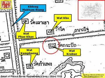
| (Detail of Phraya Boran Rachathanin's map - Anno 1926) |
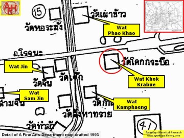
| (Detail of a 2007 Fine Arts Department GIS map - Courtesy of the Fine Arts Department - 3th Region) |