| WAT PA DAENG (วัดป่าแดง) |
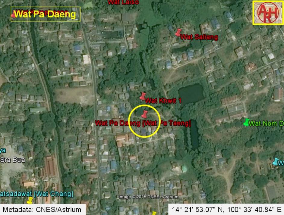
| Wat Pa Daeng is a temple ruin located off the city island in the northern area of Ayutthaya in Khlong Sra Bua Sub-district. The monastery was situated in between Khlong Pha Lai and Khlong Ban Pla Mo in area called before Thung Kaeo. Wat Khwit stood adjacent in the north, Wat Nom Duan in the east and Wat Kuti Thong in the south. Wat Pa Daeng was surrounded by water; the two canals in the east and west and connecting canals in the north and the south, separating Wat Khwit and Wat Kuti Thong. There are traces of laterite in situ, which makes it plausible, that this monastic structure could date from the Early Ayutthaya period (1351 - 1488). Written sources of the Fine Arts Department confirm that the temples in Khlong Sra Bua area - to which Wat Pa Daeng belongs - are from the Early Ayutthaya period, but of course continuously renovated until the Late Ayutthaya period (1629 - 1767). The meaning of "Pa Daeng" literally translated as "Deciduous Forest" is more or less a guess. The word Pa (ป่า) can be translated as forest but can have also the meaning of a locality, a quarter or market area. We find in Ayutthaya areas called "Green Cloth Quarter" (Pa Pha Khiao - ป่าผ้าเขียว) and "Pink Cloth Quarter" (Pa Pha Chomphu - ป่าผ้าชมพู) [1] hence Pa Daeng could be "Red Cloth Quarter" and as thus the name of the temple: the "Monastery of the Red Cloth Quarter"; especially as it is situated near Khlong Pha Lai or the "Canal of the Patterned Cloth". Wat Pa Daeng could also be established by a lineage of monks, which reached Chiangmai during the reign of King Sam Fang Kaen (r. 1401 - 1441) of Lan Na Thai (Million Rice Fields). This lineage at that time was led by the monk Medhamkara (or Nanagambhira - sources vary) and accompanied by two Sri Lankan monks. They resided at Wat Pa Daeng in Chiang Mai. By the time of King Tilokaracha (r. 1442 - 1487) the Pa Daeng monks were appointed to key positions and received substantial support for monastic centers including Wat Pa Daeng, which became the lineage's center for ordination rituals. There were indications of strong royal support for the Pa Daeng lineage, retaining the highest ranking monastic appointments of the period. [2] Buddhism was introduced to Chiang Tung from Chiang Mai in northern Thailand. The Chronicle of Wat Padaeng (Saimong Mangrai 1981) describes in detail the trip a Tai monk (Nanagambhira) who went to (Sri) Lanka in the purpose of establishing a new Buddhist order. After his re-consecration in Lanka, he went to Ayutthaya, Sukhothai, Chiang Mai and finally to Chiang Tung and established the Wat Padaeng monastery, which is still standing. [3] The two sources above indicate that Pa Daeng monks came to Ayutthaya, although it is not confirmed as yet that Wat Pa Daeng, north of Ayutthaya, had been established by this sect. In the manuscript Testimony of the king from Wat Pradu Songtham, a document likely compiled in the Early Ratanakosin period, is written that there was a land market on Patterned-Cloth Canal beside Wat Pa Daeng behind Wang Phak Jao Lao (Accommodation Palace for the Lord of the Lao) [4][5][6] On some maps the denomination seems to be written as Wat Pa Taeng (วัดป่าแตง), which in this case must refers to a melon market in the vicinity of the temple. On the FAD 2007 map this is clearly the case. Its historical background and exact period of construction are unknown. The ruin is indicated on Phraya Boran Rachathanin's map drafted in 1926 and on 1974, 1993 and 2007 Fine Arts Department (FAD) maps. The ruin is situated in Geo Coord: +14° 21' 53.07" N, +100° 33' 40.84" E. References: [1] Phanna phumisathan Phra Nakhon Sri Ayutthaya: Ekasan jak Ho Luang - Geographical description of Ayutthaya: Documents from the palace - Dr Vinai Pongsripian - Bangkok, Usakane, n. d. (2007). [2] Buddhist Learning and Textual Practice in Eighteenth-Century Lankan Monastic Culture - Princeton University Press - Anne M. Blackburn (2001)] [3] Tai Khun Buddhism and Ethnic-Religious Identity - Klemens Karlsson. [4] Geographical description of Ayutthaya: Documents from the palace - Dr Winai Pongsripian - Bangkok (2007). [5] Note on the Testimonies and the Description of Ayutthaya - Chris Baker - Journal of the Siam Society, Vol. 99, 2011 - page 77 (paragraph on KWPS). [6] Markets and Production in the City of Ayutthaya before 1767: Translation and Analysis of Part of the Description of Ayutthaya - Chris Baker - Journal of the Siam Society, Vol. 99, 2011- page 52. |

| | | | | | | | |


| Text, maps & photographs by Tricky Vandenberg - Aug 2009 Updated October 2011, November 2013, January 2015 |
| | | | | | | |
| (Remaining chedi of Wat Pa Daeng) |
| (Brickwork of Wat Pa Daeng) |
| (Buddha statue on a brick mound) |
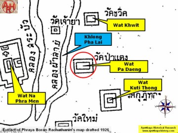
| (Detail of Phraya Boran Rachathanin's map drafted in 1926) |
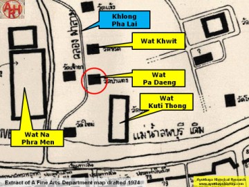
| (Detail of a 1974 Fine Arts Department map - Courtesy Dr. Surat Lertlum, Chulachomklao Royal Military Academy) |
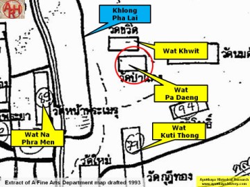
| (Detail of a 1993 Fine Arts Department map - Courtesy Khun Supot Prommanot, Director of the 3th Regional Office of Fine Arts) |


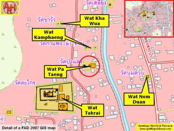
| (Detail of a 2007 Fine Arts Department GIS map - Courtesy of the Fine Arts Department - 3th Region / Be aware the position of Wat Pa Daeng on this map is wrong) |