| WAT PA FAI 1 (วัดป่าฝ้าย) |

| | | | | | | | |
| Wat Pa Fai or the Monastery of the Cotton Quarter was located on the city island of Ayutthaya in the southern part in Pratu Chai Sub-district. The former monastery was situated east of Somdet Phra Sri Nakharin Park and east of Wat Som. The temple stood in a swampy area, which was before fed by the waters of a canal with its mouth at Khlong Chakrai Yai, an extension of Khlong Tho. The area is still swampy, but is now densely habited. The monastery is indicated on Phraya Boran Rachathanin's map drafted in 1926, but no traces of it could be found; and as such classified as defunct. Historical data about the monastery and its construction are not known. Near Wat Pa Fai were two markets. A market on Iron Quarter Road selling sundries and metal goods, knives, and machetes; and another fresh market called the Head of Road Market. In front of the monastery there were shops selling books of white and black paper. [1] Wat Pa Fai was located in Geo Coord: 14° 20' 46.99" N, 100° 33' 30.41" E. References: [1] Markets and Production in the City of Ayutthaya before 1767: Translation and Analysis of Part of the Description of Ayutthaya - Chris Baker - Journal of the Siam Society, Vol. 99, 2011 - page 65-6. |
| Text & maps by Tricky Vandenberg - September 2009 Updated March 2013 |

| | | | | | | |
| (Detail of Phraya Boran Rachathanin's map - Anno 1926) |
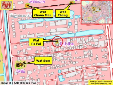
| (Detail of a 2007 Fine Arts Department GIS map - Courtesy of the Fine Arts Department - 3th Region) |
