| WAT PHUKHAO THONG (วัดภูเขาทอง) |
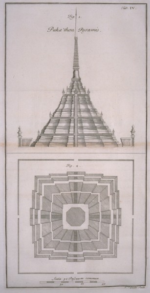
| Wat Phukhao Thong or the Monastery of the Golden Mount is located off the city island in the plains 2 Km northwest of Ayutthaya in Phukhao Thong Sub-district. The monastery was built by King Ramesuan (r. 1369-1370 / 1388-1395) in 1395. (1) The actual temple’s name refers to the high chedi on its northeast side. At the time of construction of the monastery, this chedi was inexistent; hence the temple probably had another name. In December 1568 (Reign of King Mahin / r. 1568 - 1569) a large Burmese army invaded Siam and positioned itself around Ayutthaya. The siege lagged on until 30 August 1569 and in the end the city fell through the treachery of Phya Chakri, a Siamese. The invading Burmese forces ransacked and plundered the city, dismantled the defenses, and forcibly transported most of Ayutthaya’s population to Burma. King Bhureng Noung (brother in law of Tabengshwethi) remained at Ayutthaya to witness the coronation of his vassal, Maha Thammaracha (r. 1569-1590) and started the building of a Mon-Burmese styled chedi to commemorate his victory over Ayutthaya. Bhureng Noung returned to Hongsawadi around the period that the chedi’s base was constructed. King Maha Thammaracha likely felt not too much excitement in continuing the construction of his neighbors’ victory monument and the chedi was never finalized. Prince Naresuan (r. 1590-1605) had a Thai style chedi (1) built on top of the base in 1587 to commemorate Ayutthaya's newly declared independence at Mueang Khreng in May 1584 and his victory over the Burmese (2). Engelbert Kaempfer, a medical doctor working for the Dutch VOC (Verenigde Oost- Indische Compagnie) wrote in 1690 a description of the chedi [1]: "It is a bulky, but magnificent structure, forty odd fathoms high, standing in a square taken in with a low neat wall. It consists of two structures which are built one upon the other. The lowermost structure is square, each side being one hundred and fifteen paces long, and rises to the height of twelve fathoms and upwards. Three corners jet out some few paces on each side, which are continued up to the top, and altering its square figure make it appear, as it were, multi- angular. It consists of four Stories, built one upon the other, the uppermost of which growing narrower leaves at the top of that below it an empty space, or walk to go round. Every story had its cornices curiously diversified, and all the walks, the lowermost only excepted, are taken in with low neat walls adorned in each corner with fine columns. The middlemost corner of each story represents the frontispiece of the Building. It exceeds the others in beauty and ornaments, especially in a magnificent gable it ends into. The staircase is in the middle of it, which leads up to the upper area on which is built the second structure, and consists of seventy four steps, each nine inches high, and four paces long. The second structure is built on the upper surface of the first, which is square, each side being thirty six paces long. It stands out in the middle for ornament's sake, and is taken in like the rest, with a low neat wall. It had a walk five paces broad to go about the second structure. The staircase ends into this walk, each side of its entry being adorned with columns. The basis, or pedestal of the second structure is octangular, consisting of eight sides of different length, those facing South, East, West and North, being eleven, but the North East, South East, South West, and North West sides, each twelve paces long. It had its cornices much after the manner of the lowermost structure to the height of some fathoms. It then becomes not unlike a Steeple, on whose top stand several short columns at some distances from each other, the spaces between being left empty. These columns support a pile of globes, which run up tapering, their diameters decreasing in proportion to the height. The whole ends into a very long spire, and withal so sharp, that it is very surprising, how it could hold out for so considerable a space of time against all the injuries of wind and weather." Kaempfer even added a sketch of Chedi Phukhao Thong to his writings. In the draft, we see clearly a bell-shaped dome on an octagonal base or pedestal. Over the years the upper part of the chedi fell in disrepair and collapsed. |

| | | | | | | | |


| King Boromakot (r. 1733 - 1758) had the chedi rebuilt in 1744 on a square pedestal with indented corners and niches on the four sides, running smoothly into an indented dome. This design can still be seen today. "In that year the King manifested His holy compassion by having officials restore the holy grand funeral monument as well as the holy temple of the Monastery of the Gold Mountain and they were finished after six months." In 1956, the government placed a golden ball, weighing 2,5 Kg on top of the chedi to celebrate the Buddhist religion's 25th century. Visitors can climb the Mon-Burmese styled base until the foot of the chedi, from which the surrounding rice fields and the town of Ayutthaya can be seen. The monastery The adjacent temple, founded by King Ramesuan in 1387, is still in use. There is a new structure built on the remains of the ancient ruin. The foundations and part of the pillars of the old ubosot or ordination hall are still visible. The hall is rectangular, 40 m long and 11 m wide. The building had front and back porches and two gates, east and west. Its entrance is north-east. Inside the ordination hall, you find the usual Buddha statues. There is also a Buddha footprint and in a small cave underneath (accessible through the front legs of a tiger) you find a statue of a rishi (hermit). Next to the ordination hall is a vihara measuring approx. 12 m long and 6 m wide. The single entrance faces north-east. On the south-west side are four bell-shaped chedis with indented corners at par with the principal Chedi Phukhao Thong. The chedis have also four niches, one on each side. The whole complex is surrounded by an outer wall and moat. Kaempfer refers to the monastery as follows: Next to this pyramid are some temples and colleges of the Talapoins, which are taken in with particular neat brick walls. The temples are of a very curious structure, covered with several roofs, supported by columns. Canals The temple, in earlier times, could not be reached on foot as there were no roads leading to it and the area around was very swampy. The monastery was connected with a canal to the Chao Phraya River (Khlong Yai). |
| From the Royal Chronicles of Ayutthaya we gather that a monk at Phukhao Thong, the reverend Maha Nak, left the monkhood to erect a stockade to protect the naval forces from the Burmese, approaching Ayutthaya in 1563. He erected a stockade from Wat monk united their strength with their relatives and slaves, dug a ditch, hence called Maha monk Maha Nak Canal, outside the stockade for the protection of the naval forces on the Chao Phraya River. [3] A large part of this canal is still visible southwest of the large water reservoir. A memorial park for King Naresuan has been set up in front of Phukhao Thong. H. G. Quaritch Wales wrote in his book “Siamese State Ceremonies” [5] that it appeared that there was only one spirit who was thought worthy of the royal patronage, and it was a mountain spirit. Probably this class of spirit always enjoyed a pre-eminent position, and may have been the earliest type of guardian spirit of a city. It is probable that Wat Phukhao Thong was originally a shrine dedicated to the spirit of a mountain, who was also the guardian of the city. It was the deva of the Missaka- mountain that appeared to King Devanampiyatissa of Ceylon in the form of an elk stag, and led him to Mahinda, the apostle of Buddhism. Wat Phukhao Thong is located in geographical coordinates.: 14° 22' 6.05" N, 100° 32' 21.20" E. Footnotes: (1) A feature of a Thai chedi is the row of columns over the square harmika, directly under the umbrella. (2) Kaempfer notes in Ref [1] that the chedi was built in the plains where Prince Naresuan defeated the Burmese Crown Prince. "It was built by the Siamites in remembrance of a great victory obtained in that place over the King of Pegu, whom they killed and defeated his numerous army, thereby freeing themselves of the subjection they were under to the Peguans, and restoring their ancient liberty." References: [1] The History of Japan 1690-92 by Engelbert Kaempfer. [2] Siam, the Land of the White Elephant - George B. Bacon (1893) - page 25. [3] The Royal Chronicles of Ayutthaya - Richard D. Cushman (2006) - page 32 / Source: Phan Canthanumat, British Museum, Reverend Phonnarat, Phra Cakkraphatdiphong & Royal Autograph. (War with Hongsawadi, 1563-1564) [4] Williams-Hunt Aerial Photos Collection. Original from the School of Oriental and African Studies (SOAS), University of London. Digital Data from Center for Southeast Asia Studies (CSEAS), Kyoto University. Digital Archive from Chulachomklao Royal Military Academy (CRMA), Thailand. [5] Siamese State Ceremonies - Their history and function - H.G. Quaritch Wales (1931) - London, Bernard Quaritch, Ltd. - Page 301. |

| George Bacon wrote in 1893: There is one sacred spire of immense height and size which is still kept in some kind of repair, and which is sometimes visited by the king. It is situated about four miles from the town, in the centre of a plain of paddy-fields. Boats and elephants are the only means of reaching it, as there is no road whatever, except such as the creeks and swampy paddy-fields afford. It bears much celebrity among the Siamese, on account of its height, but can boast of nothing attractive to foreigners but the fine view which is obtained from the summit. This spire, like all others, is but a succession of steps from the bottom to the top; a few ill-made images affording the only relief from the monotony of the brickwork. It bears, too, none of those ornaments, constructed of broken crockery, with which the spires and temples of Bangkok are so plentifully bedecked. [2] |
| Text, maps & photographs by Tricky Vandenberg - July 2009 Updated March 2012, March 2015 |
| (Extract from The History of Japan 1690-92 by Engelbert Kaempfer) |
| (Detail from The History of Japan 1690-92 by Engelbert Kaempfer) |


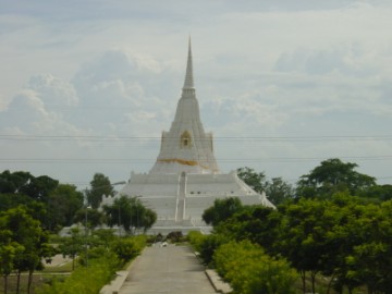
| (View Phukhao Thong seen from the Naresuan Memorial) |
| (View Phukhao Thong from the north-east) |
| (Gateway inside the chedi) |
| (View Phukhao Thong from the south-west) |
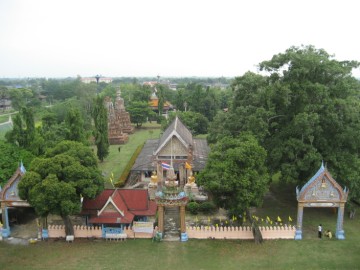
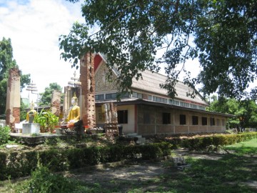
| (View of the monastery from Phukhao Thong) |
| (The ubosot or ordination hall) |
| (The vihara on the south-east) |
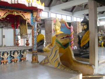
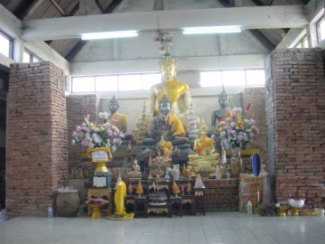
| (Inside the ubosot) |
| (Inside the ubosot) |
| (The "Hermit's cave's" entry) |
| (Rishi statue) |
| | | | | | | |
| (Luk Nimit at Wat Phukhao Thong) |
| (Chedi rai on the premises) |


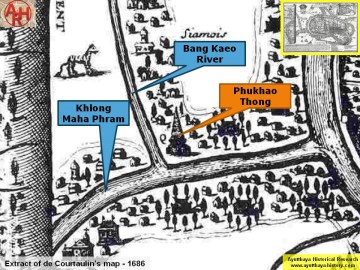
| (Chedi Phukhao Thong on Courtaulin's map - Anno 1686) |

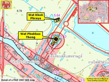
| (Detail of a 2007 Fine Arts Department GIS map - Courtesy of the Fine Arts Department - 3th Region) |


| (Source: Phra Rachawang lae Wat Boran nai Jangwat Phra Nakhon Sri Ayuthaya - 2511. Courtesy of the Fine Arts Department - 3th Region) |