| WAT RAENG 1 (วัดแร้ง) |
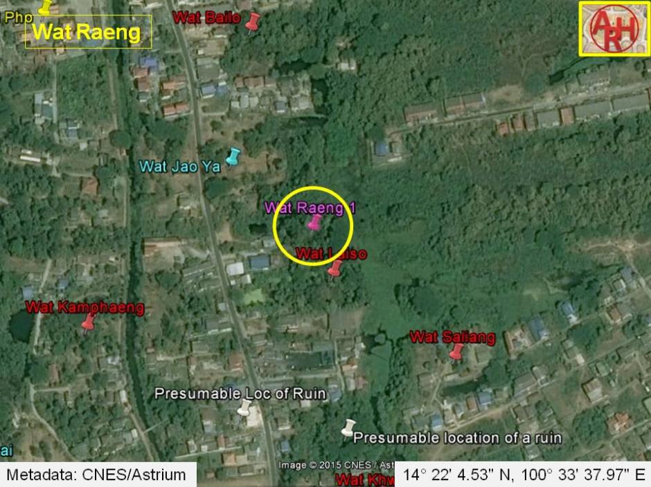
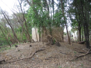
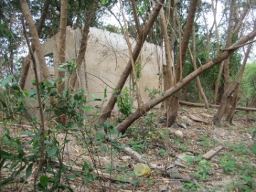
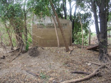
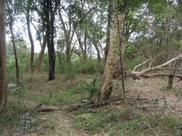
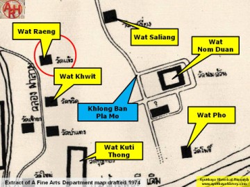
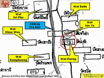
| Wat Raeng or the Monastery of the Vulture is located off the city island in the northern area of Ayutthaya in Khlong Sra Bua Sub-district. The temple was situated just south of Wat Chao Ya on the western bank of Khlong Pla Mo in an area called Thung Kaeo. This temple is indicated on different maps but not quite in the same location. On Phraya Boran Rachathanin's map (PBR) drafted in 1926 the temple is situated on the east bank of Khlong Pha Lai just north of Wat Khwit and more or less at the same level of Wat Takrai (west of Khlong Sra Bua). On a 1974 Fine Arts Department map (FAD) the monastery figures on the east bank of Khlong Pha Lai, just north of Wat Khwit and more or less at the same level of Wat Kamphaeng (along the west bank of Khlong Sra Bua). This map follows largely PBR's temple lay out. On a 1993 FAD map Wat Raeng figures on the west bank of Khlong Pla Mo in between Wat Chao Ya in the north and Wat Laiso in the south. Conclusion of the above is that the PBR 1926 and the FAD 1974 maps put Wat Raeng in the location just north of Wat Khwit on the west bank of Khlong Pla Mo. When looking on a satellite map we find a square like bushy area surrounded by water. Local villagers opposite Khlong Pla Mo stated that there was a brick mound in situ. This area was not yet visited as it is not easily accessed. On the location mentioned on the 1993 FAD map, just north of Wat Laiso, we found a brick mound. Scattered bricks all around let us presume this was an ancient temple site. On top of the mound stands a concrete structure, built somewhere twenty years ago and abandoned. Likely its builder sought a dry place to escape flooding, as this area is prone to inundation, but had to halt the construction as the site belongs to the FAD. With the exception of the clearly visible brick mound, nothing more is observed as most of the area is covered in silt. No pieces of broken Buddha images or boundary stones were seen. An uprooted tree displayed a few remnants of tiles. The site as thus must be classified as a brick mound. The site is surrounded by water on three sides, with the eastern side being Khlong Pla Mo. On the northwestern side is a pond, said to be dating from the Ayutthayan era. A wooden bridge on the north leads to the site. A local villagers told us the bridge was the initial point of access to the site from the road, but this access was now obsolete. He also told us there was even an FAD information board installed a few years ago, but now disappeared due to the flooding in 2011. The access via a bridge could indicate that the temple stood an islet before. In fact the 1926 and 1974 maps indicate Khlong Pha Lai on its western side. Wat Raeng stood as thus on its east bank. It remains though a point of discussion as Khlong Pha Lai seems to have taken a turn west towards Khlong Sra Bua and Wat Kamphaeng, north of Wat Khwit, somehow 200 meters south of this location. The remaining brick mound can be easily visited from the road, just keep right of the pond. Wat Raeng is mentioned in the Royal Chronicles of Ayutthaya and notorious in Siam's history. It was in this area that the usurper King Worawongsathirat and his queen were killed in 1548 AD by Khun Phirenthorathep, the Head of the right division of the major guard. The story goes as follows: Prince Yot Fa was the oldest son of King Chairacha (r. 1534-1547) and succeeded the throne. Due to his young age he was unable to manage the Royal affairs and Prince Thianracha and Tao Sri Sudachan, King Chairacha's non-royal concubine, acted as regents. Some conflicts between the latter two arose and Prince Thianracha entered the monkhood at Wat Rat Praditsathan, leaving the State affairs to Tao Sri Sudachan. The latter committed adultery and with intrigues arranged that her lover (with the title Worawongsa) became Regent. It was then that Queen Regent Si Sudachan hatched a plan to place her lover, Khun Worawongsa, who was only a minor palace official, onto the throne. They poisoned Prince Yot Fa in June 1548 and declared Khun Worawongsa the new king, further consolidating power by executing the nobles that dared to voice disapproval. Despite these measures, Worawongsa’s short reign would last only six weeks. Khun Phirenthorathep, a descendant from the House of Sukhothai, did not agree with the usurpation of the throne by Worawongsa. Phiren held a secret meeting with some trustees being Khun Inthorathep, Mun Ratchasena, and Luang Si Yot and decided to put Prince Thianracha on the throne. They consulted an oracle at the recitation hall of Pa Kaeo Monastery (present Wat Yai Chai Mongkhon), which turned out in the favor of Thianracha. Early January, 1549, Worawongsa announced his intention of proceeding by boat to the Elephant Kraal to see a very large elephant caught. Phiren initiated the Governors of Sawankhalok and Phijai into his plan. The royal barge of Khun Worawongsa and Queen Sri Sudachan was intercepted in a narrow creek of the Ban Pla Mo Canal, leading to the corral. The usurper King and his Queen were dragged ashore and beheaded, together with their infant daughter. Their bodies were impaled in the vicinity of the ambush, at Wat Raeng. The execution of King Worawongsathirat and his queen was thus far from royal. At that time the custom was to put the condemned in a red velvet bag and deliver them a fatal blow with a sandalwood club, preventing royal blood from touching the ground and the corpse from being seen or directly touched. Both, their royal status being in doubt and contrary to the principle, were immediately beheaded, a fast and effective way to get done with. The public display of the impaled bodies was classic for that time as a warning to all followers. The brick mound is situated in Geo Coord: 14° 22' 4.53" N, 100° 33' 37.97" E. References: [1] Thailand, a short history - David K.Wyatt (2003) - page 78. [2] The Royal Chronicles of Ayutthaya - Richard D. Cushman (2006) - page 24 & 25 / Source: Phan Canthanumat, British Museum, Reverend Phonnarat, Phra Cakkraphatdiphong & Royal Autograph. / A History of Siam - W.A.R. Wood (1924) - page 111 & 112] |

| | | | | | | | |
| | | | | | | |
| Text, maps & photographs by Tricky Vandenberg - April 2009 Reviewed January 2012, April 2015 |


| (Brick mound of Wat Raeng) |
| (Construction on top of the mound) |
| (Construction on top of the mound) |
| (Wat Raeng site view) |
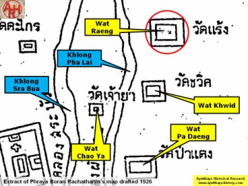
| (Detail of Phraya Boran Rachathanin's map - Anno 1926) |
| (Detail of a 1974 Fine Arts Department map - Courtesy Dr. Surat Lertlum, Chulachomklao Royal Military Academy) |
| (Detail of a 1993 Fine Arts Department map - Courtesy Khun Supot Prommanot, Director of the 3th Regional Office of Fine Arts) |