| WAT SANAM CHAI (วัดสนามไชย) |
| Wat Sanam Chai is located off the main island on the west side of the city. It can be found in close proximity east of Wat Chai Watthanaram. In fact, a small footpath connects both temples, and boats can easily dock on either site along the Chao Phraya River. Wat Sanam Chai is an active temple. Its ubosot was built from the remains of the structure that preceded it. A number of ceramic plates from China decorate the front entrance. According to monks at this temple, these plates originated from the Late Ayutthaya period, but were incorporated into the temple’s design in modern times. Some portions of the wall existed in ancient times as well, but these have also been rebuilt for the new monastery. The courtyard of Wat Sanam Chai includes several chedi from the Ayutthaya period. One of these monuments, in particular, has great historic significance. Behind the central ubosot is a Mon-like structure. This chedi is unlike any other in the city. It has multiple layers that get smaller at each level (like a pyramid). The chedi is hollow inside, and there is an altar within that showcases three old Buddha images in perfect condition. The bright red-bricks of this structure have greatly eroded, but the general structure has remained intact. Monks at this temple have explained the historical background of this chedi. It was originally build sometime during the White Elephant Wars. In 1549, the Burmese King Tabinshwehti invaded Ayutthaya after King Chakkraphat refused to present him with the gift of a white elephant. After a series of wars that followed, Siam was finally conquered by the Burmese in 1569 and became a vassal state. King Maha Thammaracha, who had a Mon background, was proclaimed the new king. The Mon-like chedi was built during the military conflicts to commemorate the Burmese soldiers that had died in battle. It had stood as a lone monument for years. Once Burmese finally claimed victory, a full monastery was built at this location. A French map drawn in 1691 by Simon de La Loubere points out that a Mon community lived in the area around Wat Sanam Chai. This may provide some evidence to collaborate the story. However, Royal Chronicles do not provide any additional information about Wat Sanam Chai’s construction. |

| | | | | | | | |
| Text by Ken May - August 2009 Photographs & maps by Tricky Vandenberg - February 2014 |
| | | | | | | |

| (View of Wat Sanam Chai) |

| (The ordination hall seen from the east) |
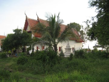
| (View of Wat Sanam Chai) |

| (The chedi of Wat Sanam Chai) |


| (Detail of a 19th century map - Courtesy Sam Chao Phraya Museum) |
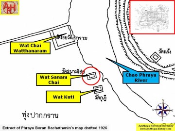
| (Detail of Phraya Boran Rachathanin's map - Anno 1926) |
| (Detail of a 2007 Fine Arts Department GIS map - Courtesy of the Fine Arts Department - 3th Region) |


