Wat Chang, or the Monastery of the Elephant, was situated on the city island in the southwestern area of Ayutthaya in the Pratu Chai Sub-district. The monastery stood on the north bank of Khlong Tha Phra. (1)
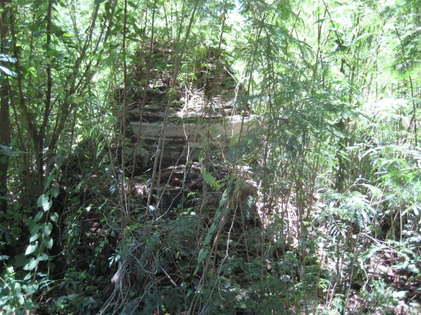
The former temple was situated just north of Wat Cho on the opposite side of the canal. In its immediate vicinity were Wat Satdichon, Wat Pa Sai and Wat Pa Sathon. In situ is a ruin covered in vegetation, lying behind private property. The foundation of a chedi with a broken spire remains visible.
Historical data about the monastery and its construction is unknown.
Maps
The 19th-century map from an unknown surveyor shows Wat Chang along Khlong Tha Phra and near the Khlong Klaep Gate (Khlong Tha Phra Gate), north of Wat Phra Ngam (opposite the canal), south of Wat Kradichon and west of Wat Jom Thong on the same side of the canal. There is no marking of a stupa.
The site is mentioned on Phraya Boran Ratchathanin's [PBR] map drafted in 1926 CE in a nearly identical position as on a 19th century map. Phraya Boran (1871-1936 CE) was the Superintendent Commissioner of Monthon Ayutthaya from 1925 till 1929 CE. PBR curiously indicates some other temples near Wat Chang: south of Wat Chang, still on the north bank of Khlong Tha Phra, he draws Wat Pa Sathon, in the south Wat Satdichon and Wat Pa Sai. On the south bank (opposite), he indicates Wat Phra Ngam and Wat Cho.
A 2007 Fine Arts Department (FAD) map based on conducted excavations shows the location as a cluster of three temples Wat Chang, Wat Satdichon and Wat Pa Sai. Wat Pa Sathon is indicated on the south bank west of Wat Cho.
I conclude that the cluster was part of one single monastery, being Wat Chang, due to their proximity.
Wat Chang is in geographical coordinates: 14° 20' 49.82" N, 100° 32' 44.99" E. For the record, the locals at the time of our visit called this location Wat Cho.