| WAT PA PHLU (วัดป่าพลู) |

| | | | | | | | |
| | | | | | | |
| Text, maps & photograph by Tricky Vandenberg - May 2009 Updated December 2013, January 2015 |
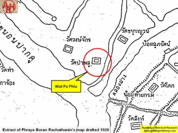
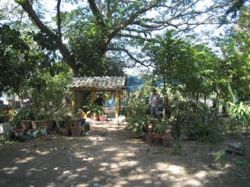
| Wat Pa Phlu or the Monastery of the Betel Quarter is at present only a small brick mound situated off the city island in the north-western area of Ayutthaya in Tha Wasukri Sub-district, west of Wat Sala Pun. In situ is a brick mound with on top a locally fabricated small sala, containing archaeological artifacts. The historical background of this temple is unknown. Wat Pa Phlu has been victim of treasure farming in earlier years. The temple is mentioned in the Royal Chronicles of Ayutthaya in connection with the digging of the Maha Nak Canal as a defensive canal prior the White Elephant War, the Burmese-Siamese war of 1563-1564. "At that time a written report from Kancanaburi came in saying that people on the frontier, having gone up to the border in the Municipality of Còiya, had learned that the King of Hongsawadi was advancing and that it had taken his men seven days to pass through Martaban. King Cakkraphat ordered that the families in the third and fourth class cities and within the districts of the province of Ayutthaya be moved into the Capital. Then a royal decree was sent up to Phitsanulok saying that, if the Hongsawadi army should at any time lay siege to Ayutthaya, Prince Thammaracha was to utilize the armies of all the cities of the north as a flanking force. Then the King sent Phraya Cakri out to establish a stockade in the Municipality of Lumphli with fifteen thousand soldiers, all of whom were clad in red tunics and red hats. The Reverend Maha Nak, who was a monk at Phukhao Thòng Monastery, left the monkhood and agreed to erect a stockade to protect the naval forces. He erected a stockade from Phukhao Thòng Monastery on down to Phlu Forest Monastery." [1] The site is indicated on Phraya Boran Rachathanin's map drafted in 1926 and situated in Geo Coord: 14° 21' 32.84" N, 100° 32' 49.25" E. References: [1] The Royal Chronicles of Ayutthaya – Richard D. Cushman (2006) - page 32 / Source: Phan Canthanumat, British Museum, Reverend Phonnarat, Phra Cakkraphatdiphong & Royal Autograph - War With Hongsawadi, 1563–1564. |
| (View of the location of Wat Pa Phlu) |
| (Detail of Phraya Boran Rachathanin's map - Anno 1926) |
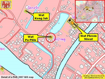
| (Detail of a 2007 Fine Arts Department GIS map - Courtesy of the Fine Arts Department - 3th Region) |
