| THE QUEST FOR THE HOLY WATER: AYUTTHAYA'S EVER-CHANGING WATERWAYS |

| | | | | | | |
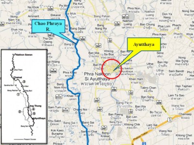
| Situated at the point confluent of three rivers, Pa Sak to the northeast, Lopburi to the north, and Chao Phraya to the east, Ayutthaya’s geographical position was perfectly suitable to be the commercial and political centre, as well as strategically easy to defend the capital from any possible invasions. Through the communication by river Ayutthaya became not only the trade centre but also the political centre of the kingdom. The artificial canals which connected every part of the capital encouraged the trade. Being at the confluence of the three rivers, Ayutthaya always had enough supply of water for the rice cultivation. The rivers also abounded in fish all through the year. In short, the geographic surroundings of Ayutthaya were perfectly ideal for the prosperity of the kingdom. The monsoon brought annually sufficient rain for the rice cultivation from May to September. The swollen rivers brought the fertile soil downstream from the north. [1] This document has been drafted to shed a bit of light on the situation of the river(s) surrounding Ayutthaya prior its fall in 1767 and thereafter. Many papers and documents state that the ancient City of Ayutthaya was located on the confluence of three rivers being the Chao Phraya, the Pa Sak and the Lopburi. This seems not to have been the case. In ancient time, all rivers were commonly called “Mae Nam” or literally “Mother of Waters”. The Siamese called their rivers after the large cities through which they flew [2]. There was no specific denomination for a full course of a river. This fact is of importance when studying old maps. We will make an attempt to denominate the old river tracks. The Chao Phraya River ran - in the 14th century - a way out to the west, where the Chao Phraya Noi River has now its riverbed; a fair 7 kilometers west of Ayutthaya. Steve Van Beeck writes that it was only in 1857 - a mere 90 years after the fall of the once magnificent city - that the Chao Phraya was deviated towards Ayutthaya. [3] We can thus exclude the Maenam Chao Phraya as one of the rivers surrounding Ayutthaya prior 1767. It was not until 1857 that an alternative path was created. A 5-kilometre channel was dug from the entrance of Wat Chulamani to Ban Mai. The river responded by following this new course and abandoning the old one, in effect making a secondary river of the stretch that ran from Ban Mai, and into the Chao Phya Noi. Half as wide as the river above and below it, the 1857 Ban Mai shunt funnels the Chao Phya down to Ayutthaya. [3] |
| | | | | | | |
| Everything is changing, everything appears and disappears. - The Enlightened One - |
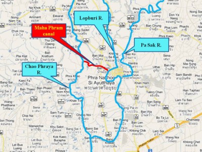
| The Maha Phram canal On a map drawn by the French Engineer La Mare (1) around 1685, we find a waterway coming in from the north-west. La Mare denominated that stretch of water with “Mapram R.”. The French had a catholic college in Tambon Maha Phram called the “Seminary of the Holy Angels”. The seminary was situated on the south bank of a canal linking the Chao Phraya River (presently Chao Phraya Noi River) with the water ring around Ayutthaya. It is obvious that this waterway - important for the French as a connecting waterway with the Saint Joseph seminary in the former Cochin Chinese area, south of Ayutthaya - was not missing on their maps. |

| The Maha Phram canal was of course not only of importance to the French at the end of the 17th century. The canal was already longtime prior in existence. King Chakkraphat used this canal to flee on a royal barge during the rebellion of Prince Sri Sin in 1561 and the rebellion of Patani in 1564. [4] This canal was dug to give Ayutthaya access to the Chao Phraya River, which - in the Ayutthayan era - was situated a few kilometers west of the city; a canal used to travel back and forth to the northern cities. The exact date of its establishment is not known. The Khlong Rop Muang (canal around the city) What about Ayutthaya’s water ring? A map in a TAT publication [5] of an undefined drawer indicates that the city was situated in the oxbow of the Pa Sak River. Whether a shunt had been dug between the Pa Sak River and the Lopburi River and hence the full course had been called the Pa Sak River on the map - or - the Lopburi ran straight into the Pa Sak River - cannot be determined on this map. Anyhow the full water ring is here indicated as being established in 1350. |
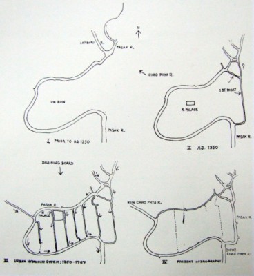
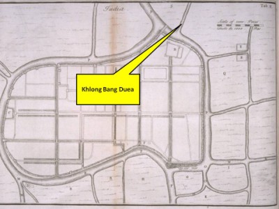
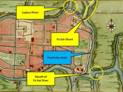
| Chakkraphat (r. 1548-1569). Late Prince Damrong Rajanubhab wrote regarding these preparations: “On this eastern side where the waters of the Sak River at that time ran along the village of Ban Ma and found an exit at the mouth of Khao San, the moat was very far from the city. (2) “It was necessary to dig an additional moat to the city, called Khlong Khuna (canal in front of the city).” [6]. Here we hear from the Father of Siamese History that a moat was dug in the east, away from the city walls, in order to set up an extra line of defense. The eastern city wall at that time was established near the present Makham Riang canal. I discussed this already in an earlier paper. In Cushman's Royal Chronicles of Ayutthaya - the Phan Canthanumat (1795) version - we read that King Chakkraphat in the period 1570-1580, "had the moat on the eastern side of the ramparts of the Royal Metropolis dug wider than the old moat, ...". The chronicles found in the British Museum were even more detailed: "He had the moat by the front ramparts on the east dug ten wa wide and three wa deep from the Maha Chai Fort at the Back Palace down to connect with Kaca Village [Canal?]". [7] Also Late Prince Damrong writes: "On the eastern side where the enemy was often able to enter the city, King Maha Thammaracha let dug an extension of the canal of the moat in front of the capital from the Mae Nang Plum monastery (i.e. from opposite the mouth of the city canal at the present day) down to the mouth of Khao San canal." [8] To be clear, the moat dug in 1568, was thus not only widened, but also enlarged on both sides in the period 1570-1580. The Chronicles state about the defense works on the eastern side of Ayutthaya in preparation of an expected Burmese attack in 1584 at the time Prince Naresuan returned from Burmese captivity: “... and having the moat on the eastern side of the city dug wider and deeper so that the river completely encircled the Royal Metropolis,…”. [9] Here we finally have a confirmation, that for the first time, Ayutthaya was fully encircled by water. The full water ring was established in 1584, about 234 years later than what is indicated on the TAT map. But what was this river encircling the city of Ayutthaya? Late Prince Damrong mentioned (as we have seen above), that in 1568 the Pa Sak River ran a few Km east of the city of Ayutthaya. Thus there remain two possibilities. The first one is that the Lopburi River and the Khlong Bang Duea - a canal or river running parallel to the Lopburi in her last stretch from Maha Rat - ran east of the city into the old Front city moat or Khu Na Muang. Khlong Bang Duea (also called Maenam Bang Duea by the local population) splits off from the Pa Sak River south of Pak Jan. The waterway ran north of the village of Bang Duea towards Ayutthaya. It is also fed by a small tributary of the Lopburi River with its mouth at Maha Rat. Whether it is a tributary from the Pa Sak River or from the Lopburi is difficult to determine. Maha Rat lies more north than Pa Jan, so I opt for the Lopburi River. The canal is presently blocked with a water gate near Wat Phra Ngam, close to its junction with the new Lopburi River at Ko Phong Phet. The Mae Nam Bang Duea ran into the eastern Front city moat (See map of Bellin). |
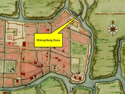
| (Khlong Bang Duea on Kaempfer's map (3)) |
| (Khlong Bang Duea on Bellin’s map) |
| The second possibility is that in 1584, the Pa Sak River was straightened and leaped east of the city in the old Front city moat. If we study Jacques Nicolas Bellin’s map (4) - probably based on notes and sketches of Engineer La Mare - we see that the French mapmaker indicated with small red arrows, the river flow. From this map we could conclude that the Lopburi River - cited here with “Le Menam”, a Siamese general term for river - provided the eastern and the western ring with water. This is an indication that the Lopburi around 1685 was the Khlong Rop Muang of Ayutthaya. |
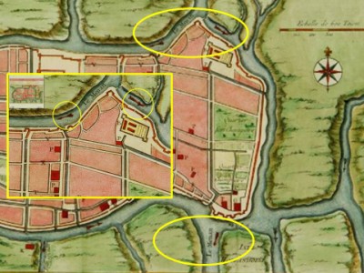
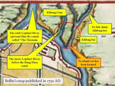
When exactly the Pa Sak River has been deviated to the Front city moat is difficult to assess. On Bellin’s map, we can see that a channel had been dug across the oxbow of the Pa Sak River, in order to cut off the meander to ease boat traffic. This meander is presently called Khlong Oom (5). At the same time of the establishment of this cutting, the “khlong lat” was linked with the Lopburi River (running into the Front city moat) via a newly dug connection canal called Khlong Sai. The period of the digging of the Pa Sak shunt must have been situated between 1584 and 1685. We observe also that the Lopburi River is drawn much wider on Bellin’s map, than the Pa Sak shunt. The Pa Sak River had clearly still its exit south of Ayutthaya and technically it was still the Lopburi River - surrounding the city - who ran in the Chao Phraya near Bang Sai. |
| The creation of the Pa Sak shunt made that somewhere later in time, the Pa Sak River changed its course into the Front city moat. The old Pa Sak River bed, meandering around Ban Ma in the east, became a canal, with different stretches presently called Khlong Hantra (from Wat Pa Kho till Wat Krasang), Khlong Kamang (from Wat Krasang till the entry of Khlong Dusit), Khlong Dusit (called after Wat Dusit on its west bank) and Khlong Khao San (with its mouth at the present Pa Sak River, being the southern end of the former Front city moat). |
| The New Lopburi River The Lopburi River was deviated near present Wat Khao Din in Bang Pahan District in the early 70’s (some sources state 2513 BE, other 2515 BE), when the Asian Highway was built. The stretch of water between Wat Muang and Wat Khao Din was filled up (6), and the Lopburi leaped into the Bang Duea canal (7). The Lopburi track between Wat Khao Din and Wat Tong Pu became known as the new Lopburi. We see on Bellin’s map, the canal is running parallel with the old Lopburi River, what will become in the second half of the 20th century the riverbed of the new Lopburi. The old Lopburi riverbed became thus a simple dead-end canal, which goes presently under different names, following the area where it runs through. The stretch between the mouth of the old Lopburi near Wat Sam Vihan and the mouth of the present Khlong Wat Tum, north of Wat Pom Raman is called Khlong Hua Ro. The stretch between the mouth of Wat Tum, north of Wat Pom Raman and the mouth of Khlong Chang near Wat Dao Khanong is called Khlong Bang Khuat (8). The stretch between Wat Dao Khanong and Wat Muang is sometimes referred to as Khlong Pho Sam Ton. |
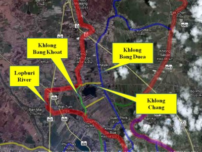
| Khlong Bang Khuat is a canal dug in the Ayutthayan era – a source stated during the reign of King Borommakot (r. 1733-1758) - to shortcut a meander in the Lopburi River. Before the digging of this canal the Lopburi ran along Wat Chang Yai, Wat Chumphon and Wat Tum. What is now called Khlong Wat Tum, was thus a stretch of the old river. Khlong Chang was a multi-purpose canal connecting two rivers between Wat Dao Khanong and Wat Ton Satu in Bang Pahan District. (9) The old Lopburi River was until the end of the 60’s still an important and heavily used waterway. The river connected the northern area of Ayutthaya with the - at that time - important Hua Ro market located in the north-eastern corner of the Ayutthaya City Island. An interviewee recalled that in his twenties, the river was packed with boats and boat traffic was dense. (10) To conclude this essay, we can state that Ayutthaya prior 1767, never had been situated at the confluence of three rivers. Ayutthaya became only a real city island at the end of the 16th century. Finally it was the Lopburi River which provided the water for the “khlong rop muang” or the canal around the city, entering the city in the north-east and leaving it in the south, to leap into the Chao Phraya near Bang Sai. Some questions remain unanswered as for example, when exactly the Pa Sak River changed its course and when Ko Chong Lom and Ko Loi were created? (This document will be updated if more information can be gathered, especially on the deviation of the Pa Sak River and the creation of Ko Chong Lom and Ko Loi. This essay can be partly viewed as a power point presentation at: http://www.ayutthaya-history.com/media/ Ayutthayas_ever- changing_waterways.pps. Any additional info can be forwarded via Facebook - discussions) Footnotes: (1) The French Engineer La Mare arrived in Siam with the Chaumont-Choisy embassy in 1685 and remained behind on request of King Narai (r. 1656- 1688) in order to upgrade Siam's fortifications. (2) Near the present location of Wat Hantra. (3) Engelbert Kaempfer (1651 - 1716), a German physician, assumed the post of medical officer to the Dutch VOC factory on Dejima in the year 1690. On his way from Batavia to Japan he resided in Siam from 06 Jun 1690 till 23 Jul 1690. The work “The History of Japan … together with a Description of the Kingdom of Siam” was written after his return to Europe, where he went into medical practice in his native town. It was written in German, but it was the English translation which appeared first in print in London in 1727. The English translation is the work of Johannes Gaspar Scheuchzer (1702 – 1729). It was not until 1777 that the first volume of the original German text was published. The work is divided into five sections with appendices. The first describes his journey from Batavia to Siam. In this work we find a most accurate map of Ayutthaya from his short visit to Siam in 1690. (4) The most accurate map of Ayutthaya was the one of the French Jacques Nicolas Bellin (1703-1772). Bellin was the official hydrographer to the French king and the first person to hold the title of "Ingénieur de la Marine du Dépôt des Cartes et Plans de la Marine" (Navy Engineer of the Office of Maps and Plans of the Navy). He published in l’Abbé Prévost's "Histoire Générale des Voyages" of 1751 a map of Ayutthaya named “Plan de la Ville de Siam, Capitale du Royaume de ce Nom; Levé par un Ingénieur François en 1687” based on sketches made probably by the French engineer Sieur de La Mare. The latter is still a point of discussion as there could been several other candidates as Tangsirivanich point out; Father Thomas Valguarnera and Jean Vollant des Verquains. Valguarnera is certainly not the drafter as he died in 1677, ten years prior to the draft of the plan. Tangsirivanich, after some careful examination, came to the conclusion that it was La Mare who engineered the plan. (5) Th: Oom is translated as "to make a turn". (6) Interview with a village headman near Wat Muang - Bang Pahan in March 2010. (7) Interview with village headman Tambon Khayai on 04 April 2010. (8) Sources: Administrative map of Ayutthaya & FAD map drafted in 1993. (9) Interview with a Buddhist priest at Wat Dao Khanong - Bang Pahan on 04 April 2010. (10) Interview with a 75 year old local near Wat Pom Raman on 03 April 2010. References: [1] Domestic Trade during the Late Ayutthaya Period - Khomkham Diwongsa -http://ayutthayastudies.aru.ac.th/content/view/525/108/ - data retrieved 15 Mar 2010. [2] The Natural and political History of the Kingdom of Siam - Nicolas Gervaise (1688) - White Lotus co. Ltd, Bangkok - page 13] [3] The Chao Phya: River in Transition - Steve Van Beeck (1994) - Oxford University Press - New York - page 12. [4] The Royal Chronicles of Ayutthaya - Richard D. Cushman (2006) - page 42 and 49 / Source: Phan Canthanumat, British Museum, Reverend Phonnarat, Phra Cakkraphatdiphong & Royal Autograph. [5] Ayutthaya: a world heritage - Tourism Authority of Thailand (2000) - Darnsutha Co Ltd - Bangkok. [6] Our Wars with The Burmese - Prince Damrong Rajanubhab (1917) - White lotus (2000) - Bangkok - War 4 page 51. [7] The Royal Chronicles of Ayutthaya - Richard D. Cushman (2006) - page 82 / Source: Phan Canthanumat & British Museum. [8] Our Wars with The Burmese - Prince Damrong Rajanubhab (1917) - Re-edited White lotus (2000) - Bangkok - War 5 page 66. [9] The Royal Chronicles of Ayutthaya - Richard D. Cushman (2006) - page 97 / Source: Phan Canthanumat, British Museum, Reverend Phonnarat, Phra Cakkraphatdiphong & Royal Autograph. |
| Essay by Tricky Vandenberg - April 2010 |
