| WAT TONG PU (วัดตองปุ) |
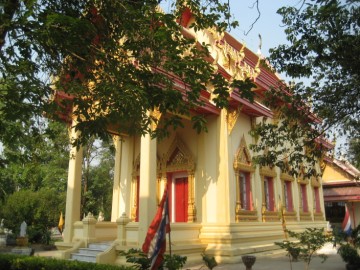
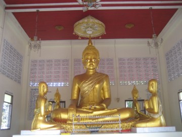
| Wat Tong Pu is an active monastery located off the city island in the northeastern area of Ayutthaya in Ban Ko Sub-district. The monastery is located at the confluence of the new Lopburi River and the new Pa Sak River, opposite Wat Chong Lom island. Wat Sakae was located on its west. All constructions on the site are from recent time with exception of the bell tower, which dates from King Narai's reign and looks identical to the one of Wat Pradu Songtham. An ancient Buddha statue (said to be from the 15th century), named Luang Pho To stood before in the ordination hall (Th: ubosot). This ordination hall became over time a ruin and the image stood in the open. In order not to damage the statue, it was decided not to reconstruct the new ubosot over it. A small vihara was constructed over the ancient statue to protect it. The new ubosot was partly built on the ruins of the old one, but a slightly extended to the west side. The hall is built in the Late Ayutthaya style. It has two elevated porches in the east and the west with each two entries to the hall. The roof is three-tiered and supported by two columns over the porches. The hall has five windows on the northern and southern sides. The main Buddha image in the ubosot faces east. Curiously the Buddha image Luang Pho To looks to the west. This is uncommon, but can be explained. The main Buddha statue of an ordination hall - the most important building of a monastery - should in principle face water, and if this is not possible, it should at least face to the east (the direction of the rising sun, is auspicious, representing life). This could mean that at the time of the construction of the image, the (new) Pa Sak River on the east side was not yet in existence (2) or it was decided to give the statue an opposite direction due to the close vicinity of Wat Sakae. The image was thus constructed facing the new Lopburi River, which must have been an existing canal in Ayutthayan times, running parallel with the old Lopburi River. The exact date of construction is unknown but according to some publication [1] the temple must have been built before the reign of King Narai (r. 1656-1688). The same source state that the vicinity of Wat Tong Pu, was a settlement area for Mon. Chinese harassment of Burma started from 1648 onward. Ten year later, with the Chinese still hanging around, agricultural activities slowed down and shortage of rice occurred. Lower Burma became disturbed. In 1661, the Prince of Prome raised an insurrection, and was crowned as King Maha Pawara Dhamma Raja. In 1662, the Governor of Martaban (1) ordered a force of 3000 men out of his municipalities, to help the King of Burma in defending Ava and to expel the Chinese. A large number of Mon escaped the force and returned to Martaban. The Governor arrested the Mon who fled back, put them in cages and threatened to burn them to death. Five thousand Mon advanced on Martaban, burned down the town and took the Governor in custody. The Talaing insurgents could hold the town for a while, but realized they would not escape the wrath of the King of Ava. The Talaings assembled their families and with more than 10.000 people started their flight to Siam in direction of the Three Pagoda Pass. A front guard advanced to Kanchanaburi in order to give account of the occurrences to King Narai. The King sent some thousand Mon troop to meet them and to guide the refugees to Kanchanaburi. [2] The Mon nobles were received for an audience at the court and arrangements were made to harbour the families in the vicinity of Sam Khok, partly near Khlong Khu Cham [4] (in the vicinity of the Monastery of the Mud of the Shell Harbor [3]) and partly in the neighborhood of the Monastery of the Card Slap [4]. A Burmese force was sent down and reoccupied Martaban. The settlement issue: 1. Sam Khok in present Pathum Thani province is well known as a former settlement location of the Mon. 2. The references [3] en [4] relate to Wat Tha Hoi (Monastery of the Landing of the Shell fish) on the east bank of Khlong Khu Cham. 3. The Monastery of the Card Slap's location could though not be traced. Reference [1] state that a number of the above Mon refugees were settled by King Narai in the vicinity of Wat Tong Pu. The latter is doubtful as the translated eight versions of the Royal Chronicles of Ayutthaya (Cushman - 2006), makes no reference of Wat Tong Pu. An old document mentions that in the Ayutthayan era there were boathouses for royal barges and for various procession boats at Wat Tong Pu as well as near Wat Prasat. [5] The site is not indicated on Phraya Boran Rachathanin's map drafted in 1926. Wat Tong Pu is located in geographical coordinates: 14° 22' 22.97" N, 100° 34' 39.26" E. Footnotes: (1) Martaban, now called Mottama is located in Thaton district of the Mon State in Myanmar. Mottama was the first capital of the Hongsawadi Kingdom in the 13th and 14th centuries. The small port of Martaban, located at the mouth of the Thanlwin across the river from Mawlamyine, was famous for its glazed pottery. (2) The Pa Sak River's old riverbed was present Khlong Hantra. References: [1] Art & Culture Magazine Silapa - March 2010 - page 52. [2] The Royal Chronicles of Ayutthaya - Richard D. Cushman (2006) - page 256 / Source: Phan Canthanumat. [3] Ibid - page 257. [4] The Royal Chronicles of Ayutthaya - Richard D. Cushman (2006) - page 258 / Source: Royal Autograph. [5] Phanna phumisathan Phra Nakhon Sri Ayutthaya: Ekasan jak Ho Luang - Geographical description of Ayutthaya: Documents from the palace - Dr Winai Pongsripian - Bangkok (2007) - page 61 / Translated by Chris Baker - Final Part of the Description of Ayutthaya - Journal of the Siam Society, Vol 102 (2014) - page 205. |

| | | | | | | | |
| | | | | | | |


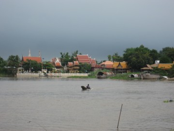
| (View from the Pa Sak River) |
| (The new ordination hall) |
| (Main Buddha image in the ordination hall) |
| (Vihara of Luang Pho To) |
| (Luang Pho To) |

| (Luang Pho To in earlier times) |
| Text & photographs by Tricky Vandenberg Updated March 2016 |


| (Detail of a 2007 Fine Arts Department GIS map - Courtesy of the Fine Arts Department - 3th Region) |
