
| | | | | | | |
| KHLONG PAK NAM MAE BIA (คลองปากนำแม่เบี้ย) |
| Text & maps by Tricky Vandenberg - January 2014 |
| | | | | | |
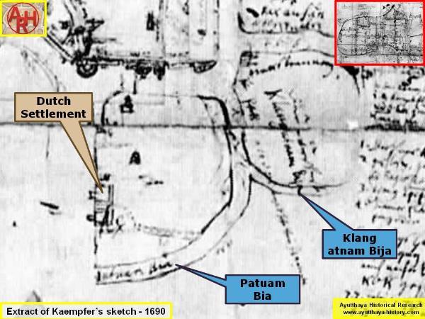
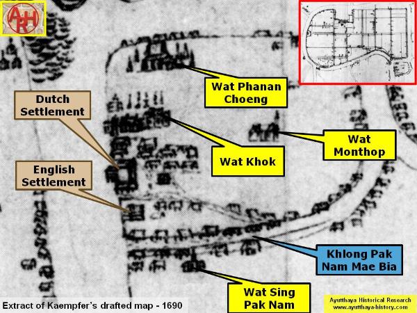
| Khlong Mae Bia or Khlong Pak Nam Mae Bia is situated off the city island in the southeastern area of Ayutthaya in Khlong Suan Phlu Sub-district. (1) The canal is in fact the western arm of Khlong Suan Phlu, which together with the latter formed the "Dutch Island" (Ko Wilanda) where the Dutch had their trade factory. The still existing, but nearly completed silted, canal has its mouth (Pak Nam) at the Chao Phraya River (2). Wat Sing Pak Nam (2) stood on the east bank of Khlong Pak Nam Mae Bia near its confluence with the "Bangkok River"; on the north bank stood the English Settlement. The Japanese settlement started just below Wat Sing Pak Nam as all the foreign settlements were really adjacent to each other, only separated by a moat or canal. On Kaempfer's sketch (1690) we find the indication "die estw... Klang atnam Bija" written next to the Suan Phlu Canal and referring to the it. At the mouth of the canal we find "Patuam bia", which could be read as Pratu Nam Bia. This reference could be interpreted that there was a water gate in 1690 at the mouth of the canal. [1] On Kaempfer's draft map (1690) we can see clearly nearly all of the temples on the "Dutch Island" as well as the English and Dutch settlements. Both banks of the canal look to have been densely inhabited. [2] On Kaempfer's published map (1727), edited by J.C. Scheuchzer, we read in the caption below "O, Arm of the river called Klang Patnam Bija" indicating the North-South stretch of Khlong Suan Phlu and the stretch running west. The stretch running east is called Khlong Wat Phra Non, a name derived from the temple along that waterway called Wat Phra Non. [3] From Kaempfer's sketch we could also deduct that today's Suan Phlu Canal could have been earlier known as Khlong Mae Bia. The mouth of Khlong Mae Bia is also indicated on Phraya Boran Rachathanin's map drafted in 1926. About 75 meters north of the canal mouth, along the Chao Phraya River, stands an old Chinese shrine dedicated to the local spirit of the land "Jao Pho Pak Nam Mae Bia". This shrine must have been situated in the immediate vicinity of the former English Settlement. Footnotes: (1) Mae bia = cobra hood; Cobra is any of various species of venomous snakes usually belonging to the family Elapidae, most of which can expand their neck ribs to form a widened hood. The name is short for cobra de capelo, which is Portuguese for "snake with hood", or "hood-snake" - Naja / Naga. (2) The Chao Phraya River here was in fact in the Ayutthayan era (1350-1767) the Lopburi River. The latter encircled the City of Ayutthaya. The stretch here was known before as the "Bangkok River". The Lopburi River joined the Chao Phraya River near Bang Sai (at present the mouth of the Noi River). (3) Freely translated as the Monastery of the Dwell at the Mouth of the River. References: [1] Barend J. Terwiel & Larry Sternstein - Prospects of Ayutthaya, Capital of Siam 1690 in Engelbert Kaempfer - Werk und Wirkung - Detlef Haberland (Stuttgart, 1993) - page 161/167. [2] Ibid - Page 160. [3] Engelbert Kaempfer - A Description of the Kingdom of Siam (1690) - Bangkok, White Orchid Press. |

| (Detail of Engelbert Kaempfer's map published in 1727) |
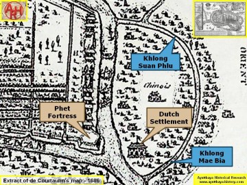
| (Detail of de Courtaulin's map - Anno1686) |
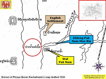
| (Detail of Phraya Boran Rachathanin's map - Anno 1926) |
| (Detail of Engelbert Kaempfer's sketch drawn in June 1690) |


| (Detail of Engelbert Kaempfer's map drawn in June 1690) |