| WAT CHANG THONG (วัดช้างทอง) |

| | | | | | | | |
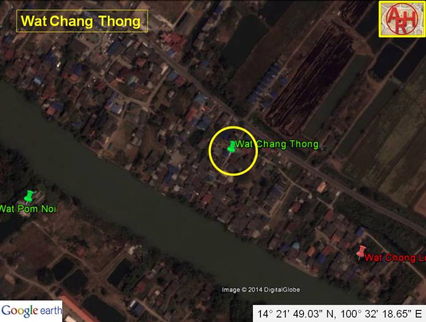
| Wat Chang Thong or the Monastery of the Golden Elephant was located off the city island in the northern area of Ayutthaya in Phukhao Thong Sub-district. The monastery features on a 1993 Fine Arts Department map only and stood north of Wat Chong Lom along the eastern canal bank of the waterway leading of the waterway leading to the old Chao Phraya River (1). Wat Chang Thong was located opposite Wat Pom Yai and Wat Pom Noi (on the other river bank) and south of Wat Phukhao Thong. The temple was squeezed in between the defensive canal Khlong Maha Nak and the canal leading to the old Chao Phraya River.. There are no traces of the monastery remaining in situ. Urbanization took its toll as a lot of new houses have been constructed in the area. Villagers used to call it Wat Tha Thong or the Monastery of the Golden Landing. Its historical background and period of construction are unknown. The monastery was approximately located in Geo Coord: 14° 21' 49.03" N, 100° 32' 18.65" E. Footnotes: (1) The old river bed of the Chao Phraya River in Bang Ban sub-district is today the Bang Ban Canal. The old Chao Phraya River could be reached from Hua Laem at the northwestern point of Ayutthaya via a stretch of the defunct Bang Kaeo River and Khlong Maha Phram. The Chao Phraya River was deviated in the mid-19th century towards Hua Laem by digging a new canal between Ban Kum and Ban Mai, running through stretches of the Bang Kaeo and Lopburi Rivers until Bang Sai. |
| Text & maps by Tricky Vandenberg - May 2009 Updated August 2011, April 2014 |
| | | | | | | |
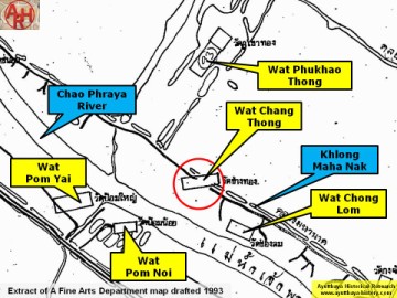
| (Detail of a 1993 Fine Arts Department map - Courtesy Khun Supot Prommanot, Director of the 3th Regional Office of Fine Arts) |