| WAT KHOK KHAMIN 2 (วัดโคกขมิ่น) |
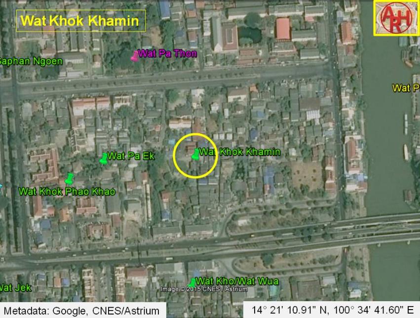
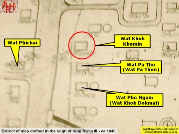
| Wat Khok Khamin or the Monastery of the Mound of the Curcuma Plant (1) was located on the city island, outside the Historical Park in the east of the city, in present Ho Ratanachai Sub-district. The monastery was situated between Khlong Nai Kai (present Khlong Makham Riang) and the Front city canal (present Pa Sak River). To its north stood Wat Pa Thon, while in the south was Wat Kho. Wat Phao Khao was situated in the southwest. No traces are anymore left of this monastery, victim of urbanization and likely brick pillage in the former centuries. Historical data about the monastery and its construction are unknown. The site is indicated on Phraya Boran Rachathanin's map drafted in 1926 and features also on a 19th century map. A 2007 Fine Arts Department map indicates Wat Khok Khamin in a location what I believe must be the site of Wat Pa Ek. The 19th century map clearly indicates two different sites being Wat Pa Ek and Wat Khok Khamin. I think Wat Khok Khamin was situated to the east of Wat Pa Ek on the same north-south axis as Wat Krabue and Wat Kho/Wat Wua. Wat Khok Khamin should have been located in Approx. Geo Coord: 14° 21' 10.91" N, 100° 34' 41.60" E. Footnotes: (1) Khamin is the Thai word for curcuma. The latter is a plant, a genus in the ginger plant family Zingiberaceae having its habitat in the warm, humid environments of south and southeast Asia. The most commercially important kind is Curcuma Longa, originating from India, widely cultivated in Asia for its underground stems. The stems are boiled for several hours and then dried in hot ovens, after which they are ground into a deep orange-yellow powder commonly used as a spice in curries and other South Asian cuisine. It is also used for dyeing and to impart color to mustard condiments. The root of turmeric (Curcuma Longa) has long been used in traditional Asian medicine to treat gastrointestinal upset, arthritic pain, and "low energy." |

| | | | | | | | |
| | | | | | | |

| Text & maps by Tricky Vandenberg - July 2010 Updated October 2010, July 2014, January 2015 |
| (Detail of Phraya Boran Rachathanin's map - Anno 1926) |
| (Detail of a mid-19th century map) |
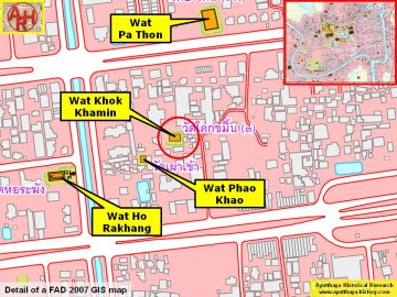
(Detail of a 2007 Fine Arts Department GIS map -
Courtesy of the Fine Arts Department - 3th Region)
Courtesy of the Fine Arts Department - 3th Region)