| WAT NOI 4 (วัดน้อย) |

| | | | | | | | |
| Wat Noi or the Little Monastery is a defunct temple situated on Ayutthaya's city island outside the Historical Park in Pratu Chai Sub-district. The monastery is mentioned on a map drafted in the mid-19th century. On that map, Wat Noi was situated south of Wat Pa Sak, at the other side of the road, an extension of Chinese Street, past Khlong Pratu Jin. On the map this extension is called Thanon Talat Jin or the Chinese Market street (Phraya Boran Rachathanin mentions this as a brick road). The map indicates the presence of a chedi. The temple was situated in between Khlong Pratu Jin and Khlong Pratu Thep Mi. Phraya Boran Rachathanin shows a structure called Tuk Rap Khaek Mueang Farangset (ตึกรับแขคเมืองฝรั่งเศส) in the area located between the two canals and below the brick road. Tuk Rap Khaek Mueang Farangset means literally the "building to receive the guests of France" and it was the place were the first French Embassy was received. The building belonged to an influent Persian Minister at that time. (1) Whether both structures were one and the same will likely remain unknown as the structure or both structures are lost in time. Historical data about the monastery and its construction are unknown. Wat Noi must have been located in the approx Geo Coord: 14° 20' 57.15" N, 100° 34' 4.00" E. Footnotes: (1) Guy Tachard wrote: "The King of Siam had ordered a stately House to be built for the Ambassador; but seeing it was not yet finished, and that there was no delay to be made because of the Season that pressed his return, Monsieur Constance went himself and pitched upon the fairest and most commodious House of the Town, which belonged to a great Mandarin, a Persian by Nation, and had it splendidly furnished." [1] References: [1] A Relation of the Voyage to Siam - Guy Tachard (1688) - Orchid Press, Bangkok (1999) - page 148. |
| Text & maps by Tricky Vandenberg - February 2011 Updated January 2015 |
| | | | | | | |
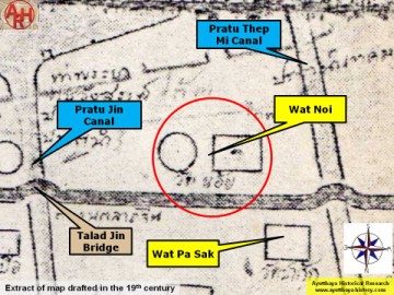
| (Detail of a 19th century map - map is orientated S-N) |
