
| | | | | | | |
| KHLONG PRATU THEP MI (คลองประตูเทพหมี) |
| Text & maps by Tricky Vandenberg - January 2014 |
| | | | | | |
| Khlong Pratu Thep Mi or the Canal of the Thep Mi Gate was situated on Ayutthaya's city island outside the Historical Park in Pratu Chai sub-district. The south-north running canal had its mouth at the old Lopburi River (1) opposite the mouth of Khlong Phraya Phan leading to Wat Phraya Kong and Wat Phraya Phan. The canal was fed by the waters of Bueng Phra Ram, which on its turn was filled by the waters of the Lopburi River via the Lam Khu Pak Sra. The canal passed the fortified city wall at the Thep Mi Gate also known as the Khao Semi Gate, a large water gate; one of the eleven water gates from the city. The canal has been largely filled up after the fall of Ayutthaya (1767) and only few traces of the waterway are left today. Starting from its mouth going north until the Talaeng Kaeng Street; on the south bank stood Wat Am Mae, Wat Pa Rong, Wat Saphan Nak and Wat Song Khon; on the north bank stood Wat Pa Sak. Engelbert Kaempfer drafted a continuously north-south canal on his 1690 map, apparently not broken by Bueng Phra Ram (or at least he did not indicate the marsh). Including the bridge over the Talaeng Kaeng Street, we find on his map four bridges crossing the southern stretch of the canal. Only the Wanon Bridge (2) remains today. Footnote: (1) In the Ayutthayan era (1350-1767 AD) the Lopburi River encircled the City of Ayutthaya. In the mid-19th century the bed of the Chao Phraya River was deviated from the vicinity of Wat Jula Mani in Ban Kum into the bed of the (now defunct) Bang Kaeo River at Ban Mai. (2) Also called the Thep Mi Bridge. |
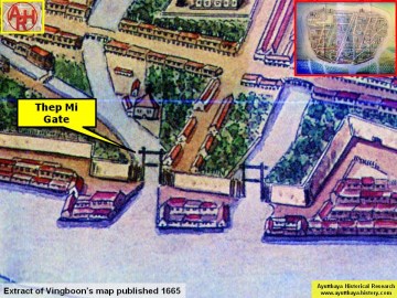
| (Thep Mi Gate on Vingboons' map - Anno 1665) |
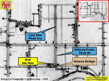
| (Detail of Engelbert Kaempfer's draft map drawn in June 1690) |
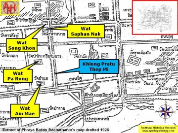
| (Detail of Phraya Boran Rachathanin's map - Anno 1926) |