| WAT PA JAN (วัดป่าจาน) |

| | | | | | | | |
| Text & maps by Tricky Vandenberg - March 2010 Updated 6 January 2014 |
| | | | | | | |
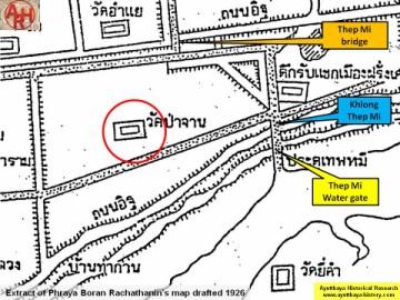
| (Detail of Phraya Boran Rachathanin's map - Anno 1926) |
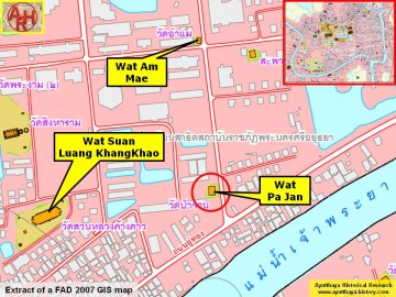
(Detail of a 2007 Fine Arts Department GIS map -
Courtesy of the Fine Arts Department - 3th Region)
Courtesy of the Fine Arts Department - 3th Region)
| Wat Pa Jan (1) was located on the city island in the southern part of Ayutthaya in Pratu Chai Sub-district. The monastery was located on the west bank of Khlong Pratu Thep Mi, a canal fed by Bueng Phra Ram and having its mouth at the present Chao Phraya River (2). Wat Am Mae lie on its north along the same canal, while Wat Singharam stood on its west. The French Reception Hall was located east, opposite the Thep Mi canal. There are no traces anymore visible of the monastery above ground level. Historical data about the monastery and its construction are unknown. The site is indicated on Phraya Boran Rachathanin's map drafted in 1926. The monastery is also known under the name of Wat Nam Jan. Wat Pa Jan was located in Geo Coord: 14° 20' 46.43" N, 100° 33' 55.22" E. Footnotes: (1) Ton Dok Jan or Butea Monosperma is a species of Butea, a genus of flowering plants belonging to the pea family, native to tropical and sub-tropical parts of the Indian Subcontinent and Southeast Asia. Known as Flame of the Forest or Bastard Teak. The name of the temple could as thus be translated as the Monastery of the Bastard Teak Forest. Another possibility is that the temple was called after a quarter in Ayutthaya producing and selling tableware. (2) In the Ayutthayan era (1350-1767 AD) the Lopburi River encircled the City of Ayutthaya. In the mid-19th century the bed of the Chao Phraya River was deviated from the vicinity of Wat Jula Mani in Ban Kum into the bed of the (now defunct) Bang Kaeo River at Ban Mai. |
