| WAT SOP SAWAN (วัดศพสวรรค์) |
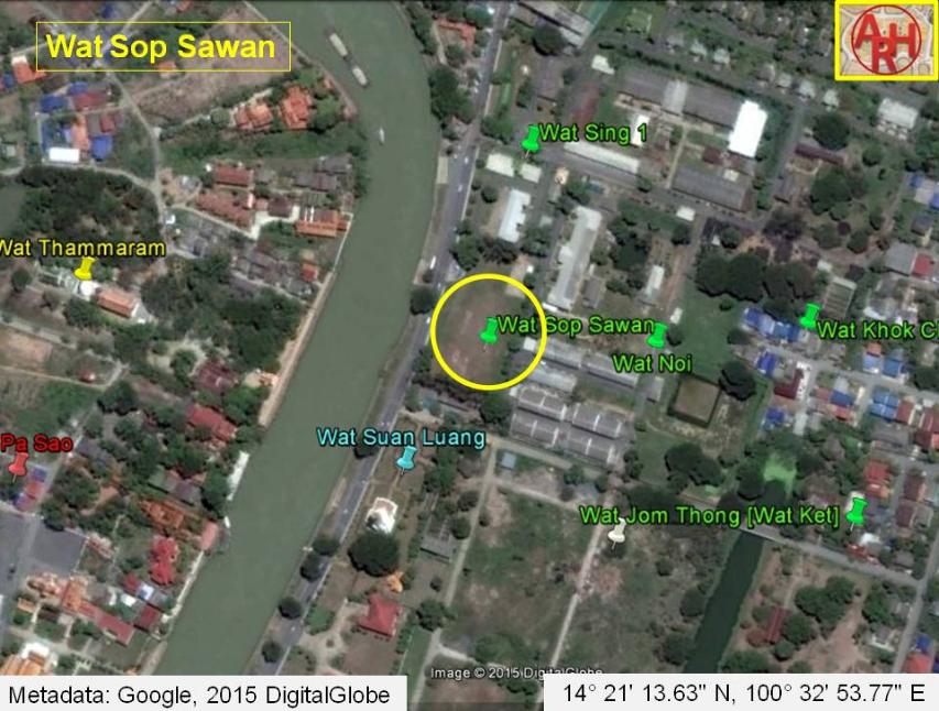
| Wat Sop Sawan was located on the western part of the city island near the confluence of the Chao Phraya River and the old Lopburi River (Khlong Mueang). This area is known as the Hua Laem District, and it is still an important area for the local military (an old cantonment was based at this site until today). Wat Sop Sawan was situated opposite of Chedi Sri Suriyothai at the mouth of a canal. The former was located on the northern side, and the latter was built on the southern side of the canal. These sites are both clearly marked on de La Mare’s 1751 map. The canal has since been filled in and has become a small road. This monastery was destroyed during the process of modernizing the city. A large memorial has been constructed at the location where it once stood. This is all that remains of it today. The Chao Sam Phraya museum has one of its sema stones on display. Royal Chronicles describe Wat Sop Sawan as it relates to a heroic woman who died in battle while saving the life of the King. As the story goes, King Chakkraphat and two of his sons were leading an army into battle against the Burmese. Queen Suriyothai, fearing for her family’s safety, secretly dressed as a male soldier and rode an elephant into the fight. While fighting a Burmese general on the back of an elephant, King Chakkraphat’s elephant stumbled, which put him at risk to his opponent’s blade. Queen Suriyothai heroically charged in front of the enemy’s weapon, sacrificing her own life in his place. Her body was then carried by boat down the Chao Phraya River to the area around this temple. In her honor, King Chakkraphat had a funeral monument and a preaching hall constructed on the site of her Royal cremation. When it was finished, the King bestowed it with the name Sop Sawan Monastery (Cushman 40-41). Wat Sop Sawan is also mentioned in Royal Chronicles as it relates to warfare. Burmese armies set up a number of stockades west of the city. One of these Burmese stockades was situated directly across the river from Wat Sop Sawan (where Wat Thammaram is located today). This strategic position put Burmese cannons within firing range of the Rear Palace (Wang Lang). As a result, Siamese troops dragged armaments to an embrasure at the Wat Sop Sawan corner and fired into the middle of the Burmese army. Cannon balls killed many elephants, horses, and soldiers (Cushman 60-61). |

| | | | | | | | |
| Text & photographs by Ken May - August 2009 |
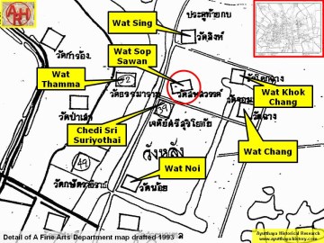
| Addendum Wat Sop Sawan is translated in Cushman's Royal Chronicles of Ayutthaya as the Monastery of the Corpses of Heaven. The monastery lied adjacent to the Monastery of the Crown Garden and is mentioned as one of the defense positions the Siamese occupied during the siege by the Burmese in 1760. When it was the fourteenth day of the waning moon in the fifth month, the Burmese brought up great guns, positioned them at the Monastery of the Royal Gift and at the Monastery of the Ruler, and fired them [CD: on] into the Capital. His Majesty the Holy Lord Omnipotent rode the premier bull elephant Defeater of a Hundred Thousand Troops to look with His [own] holy eyes at, and to give specific instructions to, the positions at the Monastery of the Crown Garden [D: , the Monastery] of the Corpses of Heaven and the Fort of Grand Victory. [1] Ex-King Uthumpon (r. 1758) left the monkhood to assist in the defense of the city. The Chronicles recall him doing an inspection of this position and others (on the 14th day of the waning moon in the 5th month) and the giving of specific instructions, after the Burmese fired their canons on the city, damaging buildings and wounding and killing people. King Suriyamarin (r. 1758-1767) ordered to answer the Burmese fire with the large guns in this position and others, on the opposite banks of the river. That evening the Burmese withdrew to the banks at the side of Wat Phukhao Thong. [1] The site is indicated on a mid-19th century map in an identical position as on Phraya Boran Rachathanin's map drafted in 1926. The mid-19th century map indicates the existence of a chedi, which at present has disappeared as the ancient monastic complex was leveled to become an army camp. Wat Sop Sawan was located just north of a boat landing called Tha Ruea Ban Jao Phraya Phonlathep in connection with Wat Thamma. Wat Sop Sawan was located in geographical coordinates: 14° 21' 13.63" N, 100° 32' 53.77" E. References: [1] The Royal Chronicles of Ayutthaya - Richard D. Cushman (2006) - page 482-3 / Source: Phan Canthanumat, British Museum & Reverend Phonnarat - The Burmese Besiege the Capital. |
| Addendum & maps by Tricky Vandenberg Updated July 2015 |
| | | | | | | |
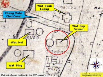
| (Detail of a 19th century map - map is orientated S-N) |
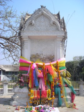
| (Wat Sop Sawan memorial) |
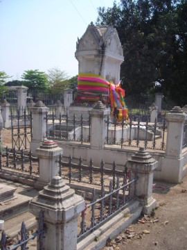
| (Wat Sop Sawan memorial) |
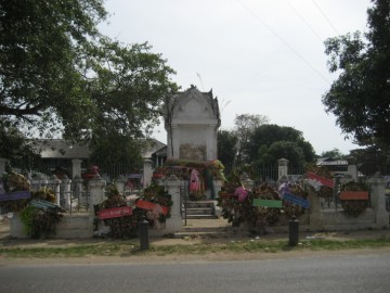
| (Wat Sop Sawan memorial) |
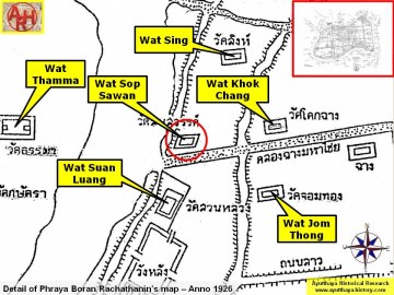
| (Detail of Phraya Boran Rachathanin's map - Anno 1926) |
| (Detail of a 1993 Fine Arts Department map - Courtesy Khun Supot Prommanot, Director of the 3th Regional Office of Fine Arts) |