| | | | | | | |
| KHLONG NAM CHIAO (คลองน้ำเชี่ยว) |
| Text by Tricky Vandenberg - August 2010 |
| | | | | | |
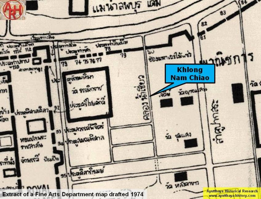
| Khlong Nam Chiao or the Canal of the Swift Water is a defunct canal which had its mouth at the northern city wall and was fed by the old Lopburi River, the present Khlong Mueang or city canal. The entry in the wall was called Chong Maha Thera Mai Sae. The canal ran in between Wat Thammikarat and Wat Yan Sen and flew into Bueng Phra Ram. It was a fast running waterway which provide fresh water to Bueng Phra Ram and made the swamp water very clear. The canal had its exit into Khlong Pratu Thep Mi, which on its turn had its mouth at the main river in the south (present Chao Phraya River) called Thep Mi Gate. [1] The canal is not mentioned on Phraya Boran Rachathanin's (PBR) map drafted in 1926 as in that time the canal mouth was already filled in and a street ran on top. [1] Although PBR mention this canal as formerly existent, this waterway is not indicated on the French Bellin map, which was based on the observations of French engineers at the end of the 17th century. Also Kaempfer fails to mention this canal on his map. Both maps though indicate the Khlong (Lam Khu) Pak Sra. Looking on the oldest post-Ayutthaya map in my possession, I also do not find traces of a canal between Wat Thammikarat and Wat Yan Sen. The above could lead to the conclusion that, what the local people before called Khlong Nam Chiao, could have been the Lam Khu Pak Sra (the waterway of the mouth of the pond). It must although be stipulated that PBR wrote that Khlong Nam Chiao was nothing more than a large gutter, which could be also the reason that it was not indicated on the different maps. References: [1] อธิบายแผนที่พระนครศรีอยุธยากับคำวินิจฉัยของพระยาโบราฌราชาธานินท์ฉบับชำระครั้งที่๒และ ภูมิสถนกรุงศรีอยุธยา (2007) - Explanation of the map of the Capital of Ayutthaya with a ruling of Phraya Boran Rachathanin - Revised 2nd edition and Geography of the Ayutthaya Kingdom - Ton Chabab print office - Nonthaburi (2007) - page 53. |