| WAT MAE NANG MUK (วัดแม่นางมุก) |
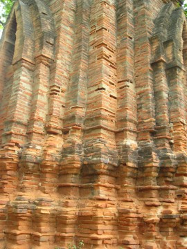
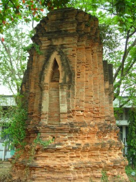
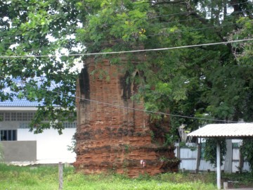
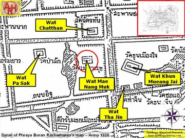
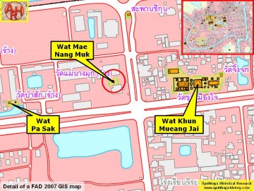
| This small ruin is hiding on the corner of Rojana Road and Chikun Road. It is situated on the property of Ayutthaya Wittayalai School. Wat Mae Nang Muk is one of the three temple ruins that is still visible at this school. The other two are Wat Pa Sak and Wat Sapan Nak. Wat Mae Nang Muk was once located next to a canal that ran from Khlong Chakrai Noi to Khlong Pratu Khao Pluak. All three canals have since been buried. This temple appears on Phraya Boran Rachathanin’s 1926 map, which shows that a small pond once existed behind it and that Muslims once lived in a nearby neighborhood (Tuk Raeb Kaek). Some versions of de La Mare’s 1751 map describe a road named “Muslim Street” in this area. This Muslim Street is documented in a number of accounts by foreigners. The canals and pond created a small island where this monastery once stood. In situ is a single chedi, which still remains partially buried underground. This chedi has been constructed in a style attributed to the Late-Ayutthaya period. Its architecture shows a Khmer influence, and it seems to be a derivative of a prang. However, this chedi has a large number of indented corners. There is an arched niche in each of the cardinal direction. Buddha images probably existed within these niches at one time, but there is no trace of them today. The history and foundation date of Wat Mae Nang Muk are unclear. This monastery remains one of the mysteries of Ayutthaya. |

| | | | | | | | |
| Text & photographs by Ken May - August 2009 |
| | | | | | | |
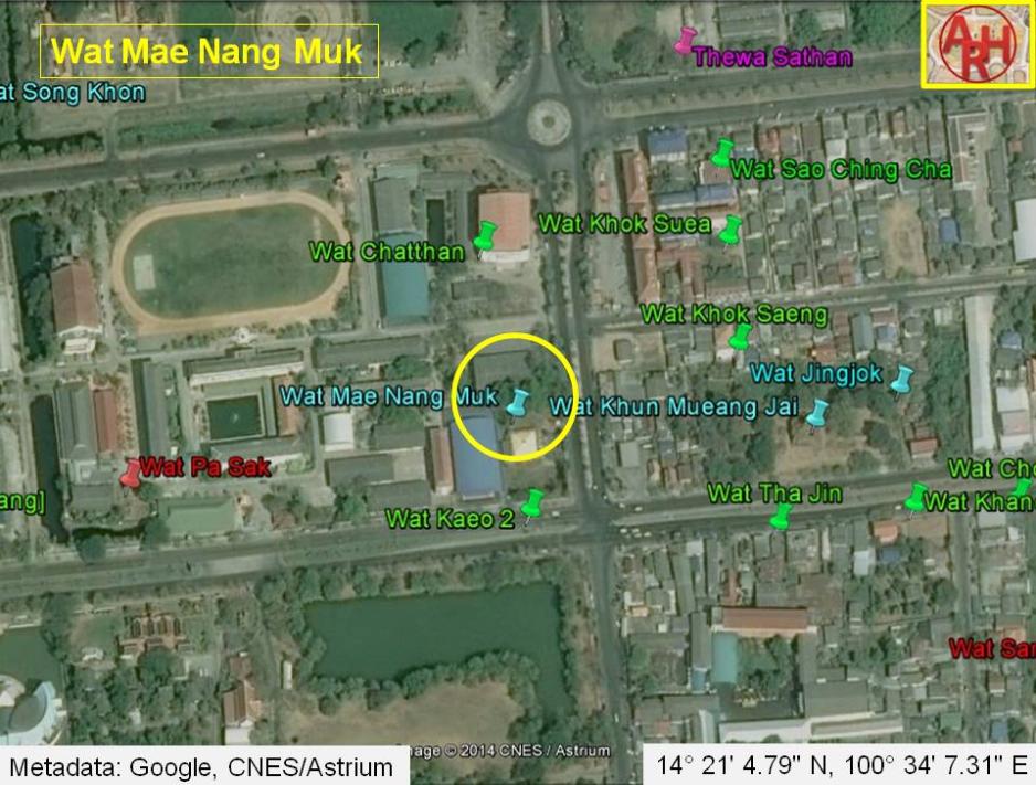
| Addendum Wat Mae Nang Muk is also indicated on a mid-19th century map but named Wat Noi Nang Muk (วัดนอยนางมุก). The monastery was situated just north of Wat Kaeo and west of Wat Sao Chingcha and Wat Khok Suea. The monastery stood on the west bank of Khlong Pratu Jin and south of Talaeng Kaeng Road and Wat Chatthan. The 19th- century map indicates the presence of a chedi. Author above, links Tuk Rap Khaek to a Muslim presence. The Thai word Khaek (แขค) refers generally to people of the Arabian peninsula, India or Pakistan, but should be interpreted here as being guest or visitor. Phraya Boran Rachathanin writes on his map Tuk Rap Khaek Mueang Farangset (ตึกรับแขคเมืองฝรั่งเศส), which means literally the building to receive the guests of France. The author however is indeed right when stating the area was a Muslim neighborhood. The building where the first French Embassy was received, belonged to an influent Persian Minister. Guy Tachard wrote: The King of Siam had ordered a stately House to be built for the Ambassador; but seeing it was not yet finished, and that there was no delay to be made because of the Season that pressed his return, Monsieur Constance went himself and pitched upon the fairest and most commodious House of the Town, which belonged to a great Mandarin, a Persian by Nation, and had it splendidly furnished. [1] There are discrepancies between the 19th century map and Phraya Boran Rachathanin's map drafted in 1926 regarding the area west of Khlong Pratu Jin. On the oldest map Wat Chatthan is situated north of Talaeng Kaeng Street instead of south. Phraya Boran Rachathanin positions in this location the Place of the Deities or Thewa Sathan. Wat Noi Nang Muk is situated at the south-west corner created by Khlong Pratu Jin and Talaeng Kaeng Street (Chikun Bridge) and is positioned on the 19C map in the location where today is believed once Wat Chatthan stood. The oldest map shows the presence of a chedi, while the remaining brickwork of Wat Mae Nang Muk is a prang. The position of today's Wat Mae Nang Muk is on the 19C map in fact Wat Kaeo. On the other hand Wat Kaeo is drafted without a chedi or prang. In conclusion, the ruin which is called Wat Mae Nang Muk today could have been Wat Kaeo. The ruin of Wat Mae Nang Muk is located in Geo Coord: 14° 21' 4.79" N, 100° 34' 7.31" E. References: [1] A Relation of the Voyage to Siam - Guy Tachard (1688) - Orchid Press, Bangkok (1999) - page 148. |
| Addendum & maps by Tricky Vandenberg - January 2011 Updated December 2014 |


| (View of the stupa of Wat Mae Nang Muk) |
| (One of the false porticos of the stupa) |
| (Twenty-rabbeted-angled chedi popular in the Late Ayutthaya period) |
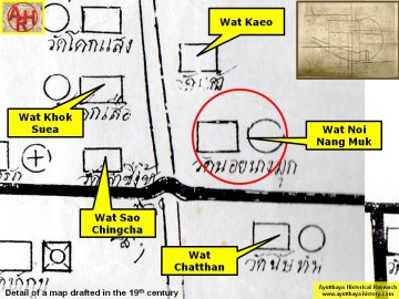
| (Detail of a 19th century map - Courtesy of the Sam Chao Phraya Museum) |
| (Detail of Phraya Boran Rachathanin's map - Anno 1926) |
| (Detail of a 2007 Fine Arts Department GIS map - Courtesy of the Fine Arts Department - 3th Region) |