| WAT WIHAN SATRU (วัดวิหารศัตรู) |

| | | | | | | | |
| Text & maps by Tricky Vandenberg Updated March 2016 |
| | | | | | | |
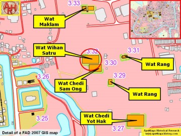
| (Detail of a 2007 Fine Arts Department GIS map - Courtesy of the Fine Arts Department - 3th Region) |
| Wat Wihan Satru was located off the city island in the eastern area of Ayutthaya in Phai Ling Sub-district. The monastery was situated south of Wat Maklam and west of Wat Khian. The site seems to be quite large with an indication of possibly an ordination hall with on the east and west sides a chedi. The premises of Wihan Satru have been severely altered in earlier times. The outer walls as well the existing chedi and probably the other monastic structures, were stripped from their bricks. Apparently the bricks were used to construct the walls of Wat Yai Chai Mongkon. The deep holes were the bricks were dug out can still been seen on site. [1] The only traces visibly above ground level are the numerous broken bricks and a remnant of a toppled chedi. Historical data about the monastery and its construction are unknown. Wat Wihan Satru is found on a 2007 Fine Arts Department adjacent to Wat Chedi Sam Ong. On a 1993 FAD map only the last can be found. Following the information gathered in situ, there was only one monastery in that location called Wat Wihan Satru. Temple brick mounds in the immediate vicinity were Khok Ta Chuai and Khok Ta Thuai. Wat Wihan Satru is located in geographical coordinates: 14° 20' 49.17" N, 100° 35' 46.87" E. References: [1] Interview with Khun Chin near Wihan Satru on 16 March 2016. |


