| WAT PA JAK (วัดป่าจาก) |

| | | | | | | | |
| Wat Pa Jak or the Monastery of the Nippa Palm Quarter (1) is a defunct temple formerly located off the city island in the southern area of Ayutthaya in Samphao Lom Sub-district in the vicinity of Bang Kraja. The monastery was situated along the Chao Phraya River between Wat Khun Phrom and Wat Nang Kui. Historical data about the monastery and its construction are unknown. The temple is mentioned in the Testimony of Khun Luang Wat Pradu Songtham. The text mentions that there was a boat ferry existing between Tha Hoi (Shell landing) and Wat Pa Jak. (2) [1] The temple is not mentioned on Phraya Boran Rachathanin's map drafted in 1926, but features on a mid-19th century map. Footnotes: (1) Nypa fruticans. (2) In Ayutthayan times there were twenty-two ferry routes between the main land and the city island. The southern area had six ferries; the five other crossings were: Wat Phanan Choeng to Hua Sarapha near the arched gateway of Talat Rong Lek, Tha Phra Rachawangsan to Wat Khun Phrom, Tha Dan Chi to Wat Surintharam, Tha Chakrai Noi to Wat Tha Rap and Tha Wang Chai to Wat Nak. [2] See "The Boat & Ferry Landings of Ayutthaya". References: [1] Khamhaikan Khun Luang Wat Pradoosongtham [the testimony of Khun Luang Wat Pradu Songtham] (2534) Bangkok: The Secretariat Office to Prime Minister - page 54. [2] Athibai Phaenthi Phra Nakhon Sri Ayutthaya kap khamwinitjai khong Phraya Boran Racha Thanin - Explanation of the map of the Capital of Ayutthaya with a ruling of Phraya Boran Rachathanin - Revised 2nd edition and Geography of the Ayutthaya Kingdom - Ton Chabab print office - Nonthaburi (2007) - page 91. |
| Text & maps by Tricky Vandenberg - October 2010 |
| | | | | | | |
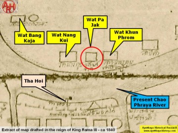
| (Detail of a 19th century map - map is orientated S-N) |
