| WAT SUAN LUANG KHANGKHAO (วัดสวนหลวงค้างคาว) |
| Wat Suan Luang Khangkhao or the Monastery of the Royal Garden of the Bat is a restored ruin situated in the vicinity of Wat Borom Phuttharam and Wat Singharam. It is located on the city island on the Rajaphat Institute premises, south of Rojana Rd and adjacent to former Khlong Chakrai Noi. The area was in the boundary of the Royal Palace of King Phetracha (r. 1688-1703) and it is assumed that this area used to be a former royal park, home to many bats; hence its name. The site includes an ordination hall (ubosot) and a chedi in Ayutthaya style. The ubosot was made of brick and plaster. It is a large construction facing east. The chedi, made of brick and plaster, was indented but actually fallen apart. Only its pedestal remains. A succession dispute occurred in Cambodia during the reign of King Phumintharacha also called King Tha Sai (r. 1709-1733), causing the King of Cambodia and his followers to request refuge in Ayutthaya. King Tha Sai granted the request and offered a settlement for the Cambodians near this temple. [1] The Supreme Holy Lord Child and Holy Older Brother of the King, at the holy age of twenty-four, ascended to be the Department of the Holy Royal Palace Enclosure of Excellence for seven years and His Majesty took the title of Holy Ruler of Kings. Routed Nak Phra In came in from the Capital of Kamphucha. The King manifested His holy compassion by having [appropriate officials] go out to meet Him and build a residence for Him to live in the vicinity of the Monastery of the Flying Foxes. [2] Its historical background and period of construction are unknown. The site was accounted for as a national ancient monument on 16 Jan 1941. References: [1] Discovering Ayutthaya - Charnvit Kasetsiri & Michael Wright (2007) - page 141. [2] The Royal Chronicles of Ayutthaya - Richard D. Cushman (2006) - page 396-7 / Source: Phra Cakkraphatdiphong - Cambodian King Comes in Exile. |

| | | | | | | | |
| Text, maps & photographs by Tricky Vandenberg - March 2009 Updated August 2015 |
| | | | | | | |
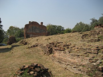
| (View of the ordination hall from the east) |
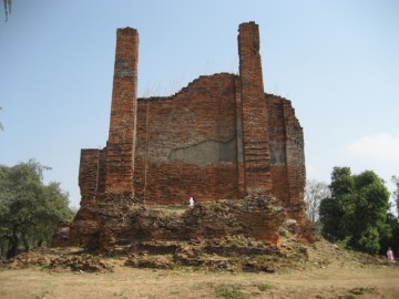
| (View of the ordination hall from the west) |
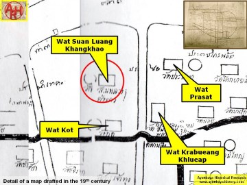
| (Detail of a 19th century map - Courtesy of the Sam Chao Phraya Museum - map is orientated S-N) |
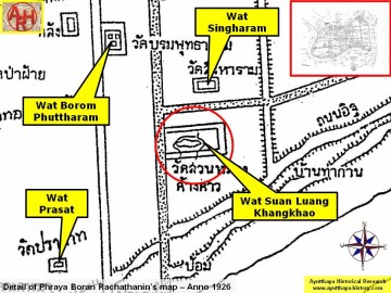
| (Detail of Phraya Boran Rachathanin's map - Anno 1926) |
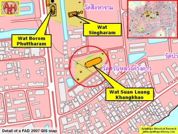
| (Detail of a 2007 Fine Arts Department GIS map - Courtesy of the Fine Arts Department - 3th Region) |


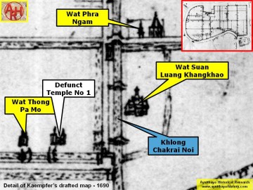
| (Detail of Engelbert Kaempfer's draft map - Anno 1690) |

| (Source: Phra Rachawang lae Wat Boran nai Jangwat Phra Nakhon Sri Ayuthaya - 2511. Courtesy of the Fine Arts Department - 3th Region) |