| | | | | | | |
| KHLONG SAI |
| Text & maps by Tricky Vandenberg - May 2011 |
| | | | | | |
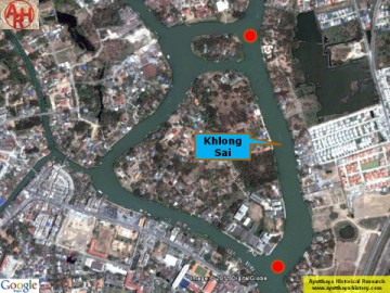
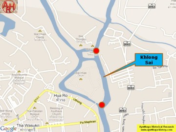
| Khlong Sai is a defunct canal once situated off the city island in the northern area Khlong Sai or Sand Canal, was a small canal cutting through the eastern main land, in front of Wat Khae and Wat Chong Lom, going south towards the present Ayutthaya Ship Building Industrial and Technology College where it joined the Front City Canal or Khlong Khue Na, in fact the Lopburi River. Wat Inthawat stood on its west bank, while Wat Nang Kham and Wat Krajom stood on its east bank. The Lopburi River and the Pa Sak River were joining near Wat Tong Pu and confluenced with Khlong Hua Ro (sometimes called the Pho Sam Ton River) in front of the Chantra Kasem Palace in the beginning of the 20th century. The erosive forces of the two rivers were destroying the embankment in front of the Chantra Kasem Palace. At that time, after having dug Khlong Chong Lom to reduce the effects of two dangerous whirlpools, the idea rose to deviate the Pa Sak River. Khlong Sai was widened and deepened. The Pa Sak River instead of running in front of Wat Tong Pu, changed its course and ran straight south from Wat Pa Kho to Wat Phanan Choeng. [1] Professor Khemnad explains in his book “Monthop” that the newly dug canal was called Khlong Jek, because the area where the canal was dug belonged to Chinese who cultivated vegetables. “Jek” [Th: เจ็ก] is an old Siamese word for Chinese people. [2] References: [1] Wat Monthop (Amphur Phra Nakhon Sri Ayutthaya) - Phayaw Khemnad (2010) - Fine Arts Department - 3th Region - page 19-20. [2] Ibid - page 23. |