| | | | | | | |
| KHLONG WAT PRADU |
| Text & photographs by Tricky Vandenberg - November 2013 |
| | | | | | |
| Khlong Wat Pradu is a defunct canal once situated off the city island in the northeastern area of Ayutthaya in Phai Ling sub-district. The Khlong Wat Pradu linked up with an important north-south canal Khlong Ayodhya - Khlong Kudi Dao, which started north at Khlong Hantra (a former stretch of the old Pa Sak River) and ran passing by Wat Kudi Dao, where further south the waterway joined Khlong Kramang. [1] Temples on its north bank (or vicinity) were from West to East: Wat Krajom, Wat Khian, Wat Pradu and Wat Jakrawan; on its south bank: Wat Nang Chi, Wat Rong Tham and Wat Kudi Dao. The canal is first seen on Engelbert Kaempfer's sketch of 1690. Kaempfer (1651-1716) has done a survey in the area around Khlong Wat Pradu and on his sketch he mentioned the different distances he measured between reference points. He likely made this survey on 19 June 1690. [2] On his sketch, Kaempfer indicated a canal slightly above the Ho Ratanachai Gate on the opposite bank of the Front city Canal. The monastery on the opposite side of the Ho Ratanachai Gate must have been Wat Nang Chi. A figure (150) appears above Wat Nang Chi giving the number of strides from the temple towards the canal. 150 steps should correspond with about 130-135 meters. The distance from the mouth to a canal running straight north towards Wat Krajom (N indicated) is 100 steps (85 m). The temple drafted at the mouth of this canal must be Wat Khian. From that side canal to the next side canal which went south (S indicated and the canal has a bridge) it was 350 steps (300 m); from the latter canal to the temple sites it was 300 steps (260 m). All together including the width of the canals we arrive at about 760 steps or 650 meters. |
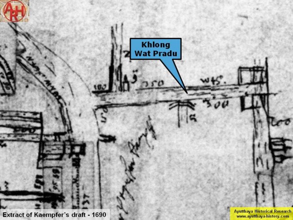
| (Detail of Engelbert Kaempfer's sketch drawn in June 1690) |
| I plotted these 650 meters on the map and arrived exactly at Wat Pradu / Wat Rong Tham (1), two monasteries opposite of each other in earlier times. There must have been a canal east of both temple sites (2) If I interpret the figure written just below the temple and next to the N-S canal as 100 steps; than the temple indicated right below, on the east bank, should be Wat Kudi Dao. |

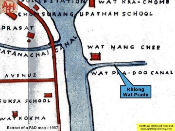
| A Fine Arts Department map of 1974 shows that the exact location of Khlong Wat Pradu was still in discussion at that time. The FAD 1974 gives two options for Khlong Wat Pradu as can be seen on the map. |
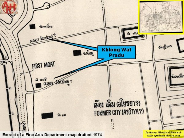
| (Detail of a Fine Arts Department map - Anno 1974) |
| As in the Ayutthayan era, a canal was often named after the most important monastery along that waterway, the northern option seems to be the most logical. Kaempfer's sketch confirms the northern canal and even points out that the old canal ran in between Wat Pradu and Wat Rong Tham (on the FAD 1974 map it runs north of Wat Pradu). Conclusions We can as thus state that Khlong Wat Pradu in earlier times ran north of Wat Nang Chi and in between between Wat Pradu and Wat Rong Tham. The canal linked up with the north-south canal parallel with Khlong Ayodhya - Khlong Kudi Dao and was situated at the west of Wat Kudi Dao (Khlong Ayodhya - Khlong Kudi Dao ran east of Wat Kudi Dao). The nomination of Khlong Wat Pradu on Phraya Boran Rachathanin's map of 1926 and on the FAD map of 1957 (with the canal mouth south of Wat Nang Chi) is wrong. The canal indicated on both maps could have been an unnamed waterway running parallel with Khlong Wat Pradu. |
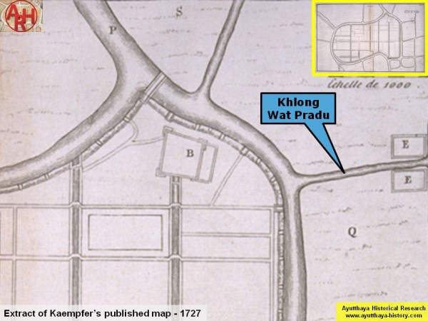
| (Detail of Kaempfer's map published in 1727 and based on his sketches and annotations of 1690) |
| The Fine Arts Department wrote on the information board at Wat Samana Kottharam that According to the Chronicle of a German naemed Gampfer, it was noted that after coming back from attacking Chiangmai, King Phet-racha went to Wat Samanakotsatharam to attend the cremation of Chaomae Watdusit in 2333 BE. …. Following Kaempfer's sketch, the cremation of Chao Mae Wat Dusit, the wet nurse of King Narai and the mother of Chao Phraya Kosa Lek and Chao Phraya Kosa Lek Pan, took place at Wat Pradu and not at Wat Samana Kottharam as stated by the Fine Arts Department. |
| On Kaempfer's published map of 1727 we find a denomination on the two temples sites marked E being "E. The Courts of Berklam’s temple". Unless Engelbert Kaempfer interpreted something wrong, Wat Pradu and Wat Rong Tham were as thus the sponsored temples by the Phrakhlang. |
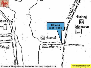
| (Detail of Phraya Boran Rachathanin's map - Anno 1926) |
| (Detail of a Fine Arts Department map - Anno 1957) |
| Footnotes: (1) The premises of Wat Rong Tham and Wat Pradu were merged to become Wat Pradu Rong Tham, presently known as Wat Pradu Song Tham. The renaming of "Rong" by "Song" seems to come from the following: "rong" which means building, sounds also as coffin (Th: long). The word "rong" was not felt as a very auspicious name for a temple, hence the name change. The same occurred to Wat Wong Khong, before known as Wat Rong Khong and later changed into Wat Wong Khong. Other Ayutthayan temples which were merged at a certain stage are Wat Sri Pho (Wat Sri Pho & Wat Kalayaram) and Wat Tha Ka Rong (Wat Tha & Wat Ka Rong). (2) This canal was running north to south and parallel with the main canal Khlong Ayodhya - Khlong Kudi Dao. Notice this canal is nearly in a straight alignment with Khlong Dusit on Kaempfer's map. Khlong Ayodhya - Khlong Kudi Dao is situated 300 meters more to the east passing west of the ruin of Wat Nang Kham. (3) Phra Khlang was the minister of foreign affairs and trade in the Ayutthayan era. References: [1] Jumsai, Sumet - The reconstruction of the city plan of Ayutthaya (1970) - The Siam Society, Bangkok - page 308. [2] Terwiel, Barend Jan - Engelbert Kaempfer in Siam (2003) - IUDICIUM Verlag GmbH Munchen - page 16. With special thanks to Chris Baker for helping me out with a number of documents. |