| WAT KHOK RAK (วัดโคกรัก) |

| | | | | | | | |
| | | | | | | |
| Text & maps by Tricky Vandenberg - July 2010 Updated October 2014 |
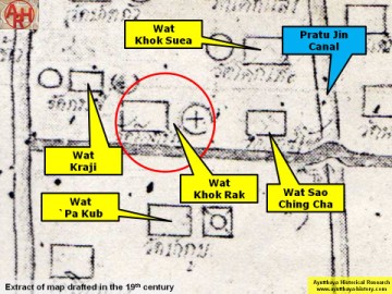
| (Detail of a 19th century map - map is orientated S-N.) |
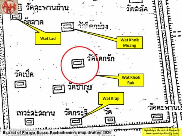
| (Detail of Phraya Boran Rachathanin's map - Anno 1926) |
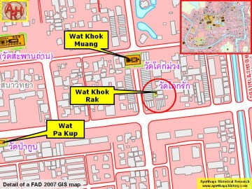
| (Detail of a 2007 Fine Arts Department GIS map - Courtesy of the Fine Arts Department - 3th Region) |
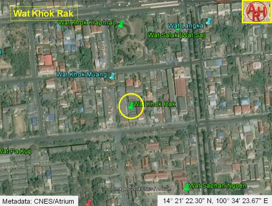
| Wat Khok Rak or the Monastery of the Mound of Crown Flower (1) was located on Ayutthaya's city island outside the Historical Park in Pratu Chai Sub-district. The temple is today defunct. The monastery was situated between Wat Khok Muang and present Khlong Makham Riang. In the north lie Wat Salak, while in the south stood Wat Kraji and Wat Saphan Ngoen. There are no traces anymore visible of the monastery above ground level. Historical data about the monastery and its construction are unknown. The monastery was situated along a road the French called "Rue des Maures" or "Moor Street", which is now more or less the present Pa Thon Rd (more or less as the ancient road did not have the width of the present lane and its direction (angle) was also probably not the same) and stood east of Wat Sao Ching Cha. Wat Kraji was located in its southeast. The site is indicated on Phraya Boran Rachathanin's (PBR) map drafted in 1926. On PBR's map the monastery was situated central between Khlong Pratu Khao Pluak and Khlong Makham Riang and pressed between Wat Khok Muang and Wat Kraji, both monasteries which have still brickwork in situ. Using an overlay we find that Wat Khok Rak on Phraya Boran Rachathanin's map coincides with the location of Wat Pet on a mid-19th century map. Wat Khok Rak is mentioned on the mid-19th century map in another location. This location coincides with the grounds of an unnamed monastery, east of Wat Kraji on PBR's map. Making an assessment of all the monastic structures, in the zone demarcated by Chikun Road, Pa Thon Road, Pridi Banomyong Road and U-Thong Road is rather difficult, as the position and name of the structures vary on different maps. On a 19th century map, there are 15 structures counted, while on the 20th century PBR map there are 13 mentioned. There is inconsistency in the names and the positions. Even maps drafted by the Fine Arts Department, what I presume, based on excavations in the zone, shed no light on this matter. Positions of monastic structures can be asserted, but their ancient names will remain questioned forever. Based on a 2007 Fine Arts Department map, Wat Khok Rak was located in geographical coordinates: 14° 21' 22.30" N, 100° 34' 23.67" E. Footnotes: (1) The monastery was likely called after the Crown flower, a flower called in Thailand "Dok Rak". Crown flower or Calotropis Gigantea is a species of Calotropis native to Thailand. It is a large shrub growing to 4 meters tall. It has clusters of waxy flowers that are either white or lavender in colour. Each flower consists of five pointed petals and a small, elegant crown rising from the centre, which holds the stamens. The plant has oval, light green leaves and milky stem. The latex of Calotropis Gigantea contains cardio glycosides, volatile fatty acids and calcium oxalate. The flowers last long, and used in Thailand for various floral arrangements. Calotropis is also a plant used in traditional medicine. [Wikipedia] |
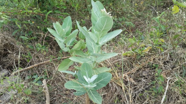
| (Crown flower or Calotropis Gigantea) |